|
|
|
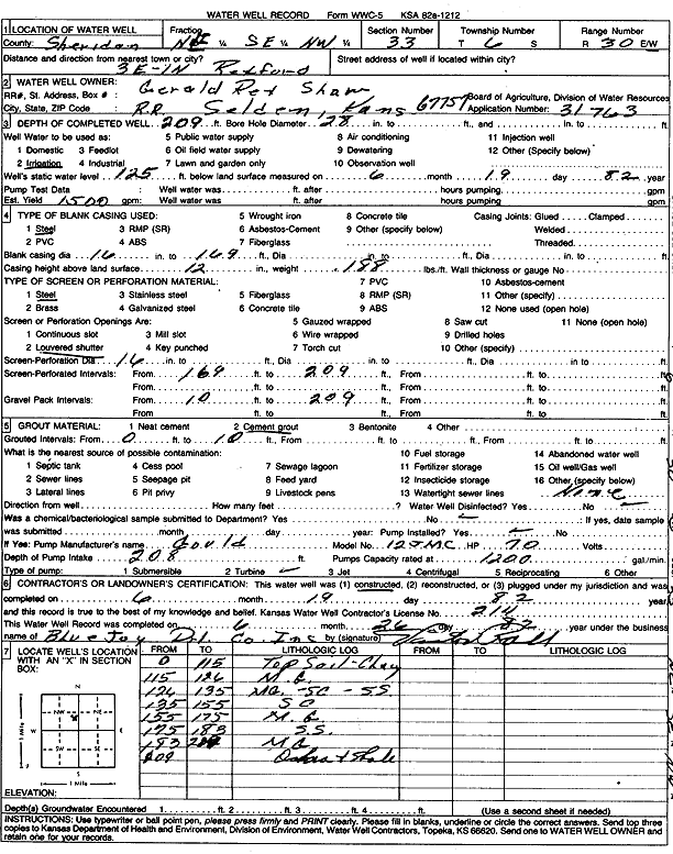
Specific Water Well Detail |
|
|
| Location Info | |||
| Owner: Shaw, Gerald Rex | Status: Constructed | ||
| Location: T6S, R30W, Sec. 33, NE SE NW | County: Sheridan | ||
| Directions: from Rexford: 3 mi E, 1 mi N | |||
| Latitude: 39.4910821 | Longitude: -100.674823 | Datum NAD 27 | |
| Latitude: 39.4910861 | Longitude: -100.6752473 | Datum NAD 83 | |
| Longitude and latitude calculated by Survey from township-range-section-quarter calls. Only good to within the quarter call accuracy. | |||
| View well on interactive map | |||
| General Info | ||
| Well Depth: 209 ft. | Elevation: ft. | |
| Static Water Level: 125 ft. | Est. Yield: 1500 gpm. | |
| Comp. Date: 19-Jun-1982 | Well Use: Irrigation | |
| DWR Applic. #: 31763 | Other ID: | |
| Links | |
| No Wizard information available. | |
| View info from WIMAS Water Right Data base... | |
| Driller Info | ||
| Driller: Blue Jay Drilling Co., Inc. | License #: 214 | |
| Scanned Form | View scan |
|
Chemical Sample Submitted?: No
Water Well disinfected?: | ||
| Ground water encountered: 0 ft. , 0 ft. , 0 ft. | ||
| Pump test data: Well water was 0 ft after 0 hours pumping 0 gpm | ||
| Casing Info | ||
| Casing Type:
Casing Joints: |
Diam: 0 in. to 0 ft
Diam: 0 in. to 0 ft Diam: 0 in. to 0 ft | |
| Casing height above land surface: in
Casing Weight: lbs/ft Wall thickness or gauge no.: | ||
| Screen and Perforation Info | ||
| Screen Type: | Screen Openings: | |
| Screen-perforated intervals | From: 169 ft to 209 ft
From: 0 ft to 0 ft From: 0 ft to 0 ft | |
| Gravel pack intervals | From: ft to ft | |
| Grout Info | ||
| Grout used: | From: 0 to 0 ft
From: 0 to 0 ft From: 0 to 0 ft | |
| Source of Possible Contamination | ||
| Source: | ||
| Direction from well: | Distance: 0 ft | |
| Lithologic Log
(Log data entered by KGS.) | ||
| From: 0 ft. to 115 ft. | Topsoil, clay | |
| From: 115 ft. to 126 ft. | Medium gravel | |
| From: 126 ft. to 135 ft. | Medium gravel, sandy clay, sandstone | |
| From: 135 ft. to 155 ft. | Sandy clay | |
| From: 155 ft. to 175 ft. | Medium gravel | |
| From: 175 ft. to 183 ft. | Sandstone | |
| From: 183 ft. to 209 ft. | Medium gravel | |
| From: 209 ft. to ft. | Ochre and shale | |