|
|
|
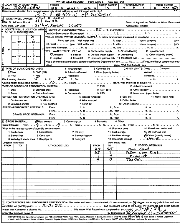
Specific Water Well Detail |
|
|
| Location Info | |||
| Owner: Shaw, Floyd | Status: Plugged | ||
| Location: T6S, R30W, Sec. 34, NE NW NE | County: Sheridan | ||
| Directions: from Selden: 3 mi S, 4.5 mi W | |||
| Latitude: 39.4945151 | Longitude: -100.6514135 | Datum NAD 27 | |
| Latitude: 39.494519 | Longitude: -100.6518371 | Datum NAD 83 | |
| Longitude and latitude calculated by Survey from township-range-section-quarter calls. Only good to within the quarter call accuracy. | |||
| View well on interactive map | |||
| General Info | ||
| Well Depth: 85 ft. | Elevation: ft. | |
| Static Water Level: ft. | Est. Yield: gpm. | |
| Comp. Date: 03-Jul-1988 | Well Use: Domestic | |
| DWR Applic. #: | Other ID: | |
| Driller Info | ||
| Driller: Floyd D. Shaw | License #: | |
| Scanned Form | View scan |
| Casing Info | ||
|
Casing Type: Steel
Diam: 5 in. Casing height above land surface: in | ||
| Grout Info | ||
| Grout used: Neat cement | From: 4 to 9 ft
From: 0 to 0 ft From: 0 to 0 ft | |
| Source of Possible Contamination | ||
| Source: | ||
| Direction from well: | Distance: 0 ft | |