|
|
|
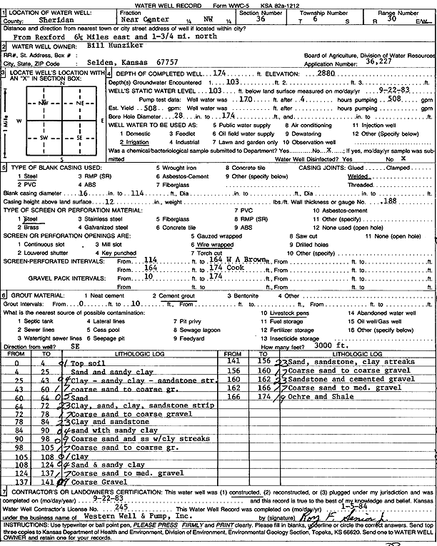
Specific Water Well Detail |
|
|
| Location Info | |||
| Owner: Hunziker, Bill | Status: Constructed | ||
| Location: T6S, R30W, Sec. 36, NW | County: Sheridan | ||
| Directions: from Rexford: 6.25 mi E, 1.75 mi N | |||
| Latitude: 39.4916669 | Longitude: -100.6221678 | Datum NAD 27 | |
| Latitude: 39.4916708 | Longitude: -100.6225906 | Datum NAD 83 | |
| Longitude and latitude calculated by Survey from township-range-section-quarter calls. Only good to within the quarter call accuracy. | |||
| View well on interactive map | |||
| General Info | ||
| Well Depth: 174 ft. | Elevation: ft. | |
| Static Water Level: 103 ft. | Est. Yield: 508 gpm. | |
| Comp. Date: 22-Sep-1983 | Well Use: Irrigation | |
| DWR Applic. #: 36,227 | Other ID: | |
| Links | |
| No Wizard information available. | |
| View info from WIMAS Water Right Data base... | |
| Driller Info | ||
| Driller: Western Well & Pump, Inc. | License #: 245 | |
| Scanned Form | View scan |
|
Chemical Sample Submitted?: No
Water Well disinfected?: | ||
| Ground water encountered: 0 ft. , 0 ft. , 0 ft. | ||
| Pump test data: Well water was 0 ft after 0 hours pumping 0 gpm | ||
| Casing Info | ||
| Casing Type:
Casing Joints: |
Diam: 0 in. to 0 ft
Diam: 0 in. to 0 ft Diam: 0 in. to 0 ft | |
| Casing height above land surface: in
Casing Weight: lbs/ft Wall thickness or gauge no.: | ||
| Screen and Perforation Info | ||
| Screen Type: | Screen Openings: | |
| Screen-perforated intervals | From: 114 ft to 164 ft
From: 164 ft to 174 ft From: 0 ft to 0 ft | |
| Gravel pack intervals | From: ft to ft | |
| Grout Info | ||
| Grout used: | From: 0 to 0 ft
From: 0 to 0 ft From: 0 to 0 ft | |
| Source of Possible Contamination | ||
| Source: | ||
| Direction from well: | Distance: 0 ft | |
| Lithologic Log
(Log data entered by KGS.) | ||
| From: 0 ft. to 4 ft. | Top soil | |
| From: 4 ft. to 25 ft. | Sand and sandy clay | |
| From: 25 ft. to 43 ft. | Clay, sandy clay, sandstone streak | |
| From: 43 ft. to 60 ft. | Coarse sand to coarse gravel | |
| From: 60 ft. to 64 ft. | Sand | |
| From: 64 ft. to 72 ft. | Clay, sand clay, sandstone strip | |
| From: 72 ft. to 78 ft. | Coarse sand to coarse gravel | |
| From: 78 ft. to 84 ft. | Clay and sandstone | |
| From: 84 ft. to 90 ft. | Sand with sandy clay | |
| From: 90 ft. to 98 ft. | Coarse sand and ss with clay streaks | |
| From: 98 ft. to 105 ft. | Coarse sand to coarse gravel | |
| From: 105 ft. to 108 ft. | Clay | |
| From: 108 ft. to 124 ft. | Sand and sandy clay | |
| From: 124 ft. to 137 ft. | Coarse and to medium gravel | |
| From: 137 ft. to 141 ft. | Coarse gravel | |
| From: 141 ft. to 156 ft. | Sand, sandstone, clay streaks | |
| From: 156 ft. to 160 ft. | Coarse sand to coarse gravel | |
| From: 160 ft. to 162 ft. | Sandstone and cemented gravel | |
| From: 162 ft. to 166 ft. | Coarse sand to medium gravel | |
| From: 166 ft. to 174 ft. | Ochre and shale | |