|
|
|
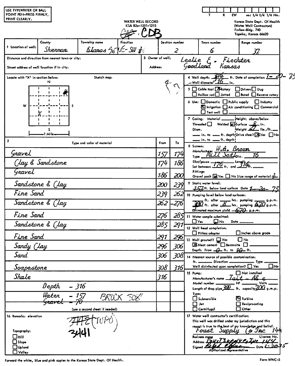
Specific Water Well Detail |
|
|
| Location Info | |||
| Owner: Fiechter, Leslie | Status: Constructed | ||
| Location: T6S, R37W, Sec. 2, SW NE SW | County: Sherman | ||
| Directions: | |||
| Latitude: 39.5589804 | Longitude: -101.4204753 | Datum NAD 27 | |
| Latitude: 39.5589792 | Longitude: -101.4209172 | Datum NAD 83 | |
| Longitude and latitude calculated by Survey from township-range-section-quarter calls. Only good to within the quarter call accuracy. | |||
| View well on interactive map | |||
| General Info | ||
| Well Depth: 316 ft. | Elevation: ft. | |
| Static Water Level: 157 ft. | Est. Yield: 670 gpm. | |
| Comp. Date: 20-Jan-1975 | Well Use: Irrigation | |
| DWR Applic. #: | Other ID: | |
| Links | |
| View info from Wizard Water Level Data base... | |
| View info from WIMAS Water Right Data base... | |
| Driller Info | ||
| Driller: A.J. Foust Supply Co. Inc. | License #: 144 | |
| Scanned Form | View scan |
|
Chemical Sample Submitted?: No
Water Well disinfected?: | ||
| Ground water encountered: 0 ft. , 0 ft. , 0 ft. | ||
| Pump test data: Well water was 0 ft after 0 hours pumping 0 gpm | ||
| Casing Info | ||
| Casing Type:
Casing Joints: |
Diam: 0 in. to 0 ft
Diam: 0 in. to 0 ft Diam: 0 in. to 0 ft | |
| Casing height above land surface: in
Casing Weight: lbs/ft Wall thickness or gauge no.: | ||
| Screen and Perforation Info | ||
| Screen Type: | Screen Openings: | |
| Screen-perforated intervals | From: 176 ft to 316 ft
From: 0 ft to 0 ft From: 0 ft to 0 ft | |
| Gravel pack intervals | From: ft to ft | |
| Grout Info | ||
| Grout used: | From: 0 to 0 ft
From: 0 to 0 ft From: 0 to 0 ft | |
| Source of Possible Contamination | ||
| Source: | ||
| Direction from well: | Distance: 0 ft | |
| Lithologic Log
(Log data entered by KGS.) | ||
| From: 157 ft. to 174 ft. | Gravel | |
| From: 174 ft. to 186 ft. | Clay and sandstone | |
| From: 186 ft. to 200 ft. | Gravel | |
| From: 200 ft. to 239 ft. | Sandstone and clay | |
| From: 239 ft. to 262 ft. | Fine sand | |
| From: 262 ft. to 276 ft. | Sandstone and clay | |
| From: 276 ft. to 285 ft. | Fine sand | |
| From: 285 ft. to 291 ft. | Sandstone and clay | |
| From: 291 ft. to 296 ft. | Fine sand | |
| From: 296 ft. to 306 ft. | Sandy clay | |
| From: 306 ft. to 308 ft. | Sand | |
| From: 308 ft. to 316 ft. | Soapstone | |
| From: 316 ft. to ft. | Shale | |