|
|
|
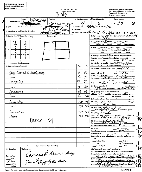
Specific Water Well Detail |
|
|
| Location Info | |||
| Owner: Deeds, Harold | Status: Constructed | ||
| Location: T6S, R37W, Sec. 4, NW NW NW | County: Sherman | ||
| Directions: From Edson, 4 miles East and 16 miles North | |||
| Latitude: 39.5675028 | Longitude: -101.4624199 | Datum NAD 27 | |
| Latitude: 39.5675011 | Longitude: -101.4628627 | Datum NAD 83 | |
| Longitude and latitude calculated by Survey from township-range-section-quarter calls. Only good to within the quarter call accuracy. | |||
| View well on interactive map | |||
| General Info | ||
| Well Depth: 179 ft. | Elevation: ft. | |
| Static Water Level: 45 ft. | Est. Yield: 10 gpm. | |
| Comp. Date: 15-May-1978 | Well Use: Domestic, Livestock | |
| DWR Applic. #: | Other ID: | |
| Driller Info | ||
| Driller: A.J. Foust Supply Co. Inc. | License #: 144 | |
| Scanned Form | View scan |
|
Chemical Sample Submitted?: No
Water Well disinfected?: | ||
| Ground water encountered: 0 ft. , 0 ft. , 0 ft. | ||
| Pump test data: Well water was 0 ft after 0 hours pumping 0 gpm | ||
| Casing Info | ||
| Casing Type:
Casing Joints: |
Diam: 0 in. to 0 ft
Diam: 0 in. to 0 ft Diam: 0 in. to 0 ft | |
| Casing height above land surface: in
Casing Weight: lbs/ft Wall thickness or gauge no.: | ||
| Screen and Perforation Info | ||
| Screen Type: | Screen Openings: | |
| Screen-perforated intervals | From: 159 ft to 179 ft
From: 0 ft to 0 ft From: 0 ft to 0 ft | |
| Gravel pack intervals | From: ft to ft | |
| Grout Info | ||
| Grout used: | From: 0 to 0 ft
From: 0 to 0 ft From: 0 to 0 ft | |
| Source of Possible Contamination | ||
| Source: | ||
| Direction from well: | Distance: 0 ft | |
| Lithologic Log
(Log data entered by KGS.) | ||
| From: 0 ft. to 60 ft. | Clay, gravel, and sandy clay | |
| From: 60 ft. to 70 ft. | Sand | |
| From: 70 ft. to 76 ft. | Sandy clay | |
| From: 76 ft. to 82 ft. | Sand | |
| From: 82 ft. to 89 ft. | Sandstone | |
| From: 89 ft. to 110 ft. | Sand | |
| From: 110 ft. to 150 ft. | Sandy clay | |
| From: 150 ft. to 174 ft. | Sand | |
| From: 174 ft. to 179 ft. | Soapstone | |
| From: 179 ft. to 180 ft. | Shale | |