|
|
|
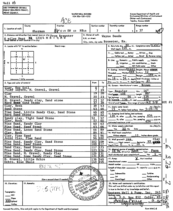
Specific Water Well Detail |
|
|
| Location Info | |||
| Owner: Deeds, Wayne | Status: Constructed | ||
| Location: T6S, R37W, Sec. 7, NW SW NE | County: Sherman | ||
| Directions: from Brewster, 6 mi W, 12.75 mi N, and 0.25 mi W | |||
| Latitude: 39.5500392 | Longitude: -101.4903425 | Datum NAD 27 | |
| Latitude: 39.5500374 | Longitude: -101.490786 | Datum NAD 83 | |
| Longitude and latitude calculated by Survey from township-range-section-quarter calls. Only good to within the quarter call accuracy. | |||
| View well on interactive map | |||
| General Info | ||
| Well Depth: 146 ft. | Elevation: ft. | |
| Static Water Level: 13 ft. | Est. Yield: 654 gpm. | |
| Comp. Date: 20-May-1976 | Well Use: Irrigation | |
| DWR Applic. #: | Other ID: | |
| Links | |
| View info from Wizard Water Level Data base... | |
| View info from WIMAS Water Right Data base... | |
| Driller Info | ||
| Driller: Western Well & Pump, Inc. | License #: 245 | |
| Scanned Form | View scan |
|
Chemical Sample Submitted?: No
Water Well disinfected?: | ||
| Ground water encountered: 0 ft. , 0 ft. , 0 ft. | ||
| Pump test data: Well water was 0 ft after 0 hours pumping 0 gpm | ||
| Casing Info | ||
| Casing Type:
Casing Joints: |
Diam: 0 in. to 0 ft
Diam: 0 in. to 0 ft Diam: 0 in. to 0 ft | |
| Casing height above land surface: in
Casing Weight: lbs/ft Wall thickness or gauge no.: | ||
| Screen and Perforation Info | ||
| Screen Type: | Screen Openings: | |
| Screen-perforated intervals | From: 56 ft to 46 ft
From: 0 ft to 0 ft From: 0 ft to 0 ft | |
| Gravel pack intervals | From: ft to ft | |
| Grout Info | ||
| Grout used: | From: 0 to 0 ft
From: 0 to 0 ft From: 0 to 0 ft | |
| Source of Possible Contamination | ||
| Source: | ||
| Direction from well: | Distance: 0 ft | |
| Lithologic Log
(Log data entered by KGS.) | ||
| From: 0 ft. to 7 ft. | Clay, top soil | |
| From: 7 ft. to 19 ft. | Clay layers, medium gravel, gravel | |
| From: 19 ft. to 20 ft. | Clay | |
| From: 20 ft. to 23 ft. | Medium gravel, gravel | |
| From: 23 ft. to 37 ft. | Medium gravel, sandy clay, sandstone | |
| From: 37 ft. to 39 ft. | Sandstone, hard | |
| From: 39 ft. to 43 ft. | Clay, rock | |
| From: 43 ft. to 46 ft. | Sandstone | |
| From: 46 ft. to 49 ft. | Fine sand, little sandy clay, sandstone | |
| From: 49 ft. to 52 ft. | Sandstone, hard | |
| From: 52 ft. to 57 ft. | Sandy clay, tight sandstone | |
| From: 57 ft. to 60 ft. | Clay, rock | |
| From: 60 ft. to 63 ft. | Fine sand, sandy clay | |
| From: 63 ft. to 66 ft. | Fine sand, sandstone | |
| From: 66 ft. to 89 ft. | Fine sand, loose sandstone | |
| From: 89 ft. to 91 ft. | Clay, rock | |
| From: 91 ft. to 96 ft. | Clay, fine sand | |
| From: 96 ft. to 102 ft. | Joint clay, fine sand | |
| From: 102 ft. to 109 ft. | Fine sand, sandy clay, sandstone | |
| From: 109 ft. to 117 ft. | Fine sand, sandstone | |
| From: 117 ft. to 123 ft. | Sand clay, sandstone | |
| From: 123 ft. to 126 ft. | Fine sand, sandy clay, sandstone | |
| From: 126 ft. to 131 ft. | Fine sand, medium gravel, sandy clay | |
| From: 131 ft. to 136 ft. | Fine sand, some sandy clay, sandstone | |
| From: 136 ft. to 140 ft. | Medium gravel, little ochre | |
| From: 140 ft. to 146 ft. | Ochre, blue shale | |