|
|
|
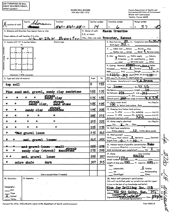
Specific Water Well Detail |
|
|
| Location Info | |||
| Owner: Cremrine, Mason | Status: Constructed | ||
| Location: T6S, R37W, Sec. 14, NW NW NE | County: Sherman | ||
| Directions: From Brewster, 11.5 miles North and 2.5 miles West | |||
| Latitude: 39.5394947 | Longitude: -101.4160317 | Datum NAD 27 | |
| Latitude: 39.5394937 | Longitude: -101.4164736 | Datum NAD 83 | |
| Longitude and latitude calculated by Survey from township-range-section-quarter calls. Only good to within the quarter call accuracy. | |||
| View well on interactive map | |||
| General Info | ||
| Well Depth: 312 ft. | Elevation: ft. | |
| Static Water Level: 100 ft. | Est. Yield: 700 gpm. | |
| Comp. Date: 30-Jun-1975 | Well Use: Irrigation | |
| DWR Applic. #: | Other ID: | |
| Links | |
| View info from Wizard Water Level Data base... | |
| View info from WIMAS Water Right Data base... | |
| Driller Info | ||
| Driller: Blue Jay Drilling Co., Inc. | License #: 214 | |
| Scanned Form | View scan |
|
Chemical Sample Submitted?: No
Water Well disinfected?: | ||
| Ground water encountered: 0 ft. , 0 ft. , 0 ft. | ||
| Pump test data: Well water was 0 ft after 0 hours pumping 0 gpm | ||
| Casing Info | ||
| Casing Type:
Casing Joints: |
Diam: 0 in. to 0 ft
Diam: 0 in. to 0 ft Diam: 0 in. to 0 ft | |
| Casing height above land surface: in
Casing Weight: lbs/ft Wall thickness or gauge no.: | ||
| Screen and Perforation Info | ||
| Screen Type: | Screen Openings: | |
| Screen-perforated intervals | From: 272 ft to 312 ft
From: 0 ft to 0 ft From: 0 ft to 0 ft | |
| Gravel pack intervals | From: ft to ft | |
| Grout Info | ||
| Grout used: | From: 0 to 0 ft
From: 0 to 0 ft From: 0 to 0 ft | |
| Source of Possible Contamination | ||
| Source: | ||
| Direction from well: | Distance: 0 ft | |
| Lithologic Log
(Log data entered by KGS.) | ||
| From: 0 ft. to 155 ft. | Top soil | |
| From: 155 ft. to 175 ft. | Fine sand, medium gravel, sandy clay, sandstone | |
| From: 175 ft. to 185 ft. | Fine sand, medium gravel, sandy clay streak | |
| From: 185 ft. to 195 ft. | Fine sand, sandy clay streak, sandstone streak | |
| From: 195 ft. to 205 ft. | Fine sand, sandy clay, sandstone streak | |
| From: 205 ft. to 215 ft. | Fine sand, sandy clay, sandstone streak | |
| From: 215 ft. to 225 ft. | Fine sand, sandy clay, sandstone streak | |
| From: 225 ft. to 235 ft. | Fine sand, sandy clay, sandstone streak | |
| From: 235 ft. to 245 ft. | Fine sand, medium gravel, loose | |
| From: 245 ft. to 255 ft. | Fine sand, medium gravel, looser | |
| From: 255 ft. to 275 ft. | Fine sand, medium gravel, loose | |
| From: 275 ft. to 295 ft. | Fine sand, sandy clay streak, small sandstone streak | |
| From: 295 ft. to 307 ft. | Fine sand, medium gravel, loose | |
| From: 307 ft. to 315 ft. | Fine sand, ochre shale, dark | |