|
|
|
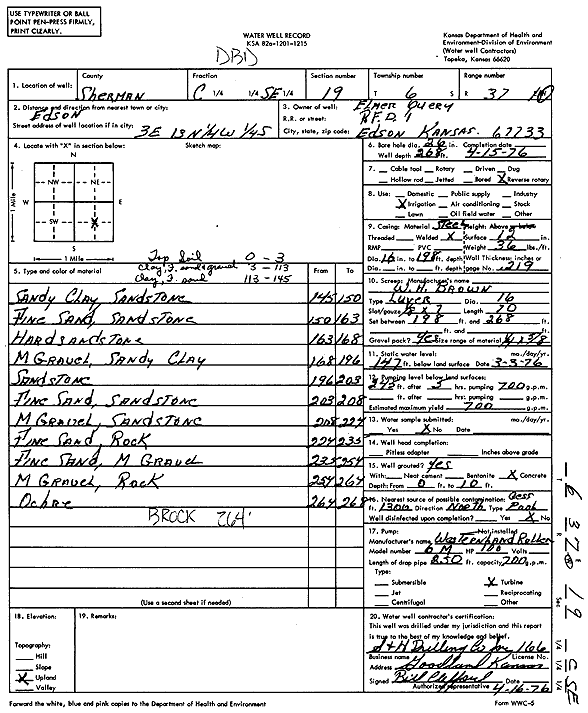
Specific Water Well Detail |
|
|
| Location Info | |||
| Owner: Query, Elmer | Status: Constructed | ||
| Location: T6S, R37W, Sec. 19, C SE | County: Sherman | ||
| Directions: from Edson, 3 mi E, 13 mi N, 0.25 mi W, and 0.25 mi S | |||
| Latitude: 39.5148324 | Longitude: -101.4875724 | Datum NAD 27 | |
| Latitude: 39.5148311 | Longitude: -101.488016 | Datum NAD 83 | |
| Longitude and latitude calculated by Survey from township-range-section-quarter calls. Only good to within the quarter call accuracy. | |||
| View well on interactive map | |||
| General Info | ||
| Well Depth: 268 ft. | Elevation: ft. | |
| Static Water Level: 147 ft. | Est. Yield: 700 gpm. | |
| Comp. Date: 15-Apr-1976 | Well Use: Irrigation | |
| DWR Applic. #: | Other ID: | |
| Links | |
| View info from Wizard Water Level Data base... | |
| View info from WIMAS Water Right Data base... | |
| Driller Info | ||
| Driller: S & H Drilling Co., Inc. | License #: 166 | |
| Scanned Form | View scan |
|
Chemical Sample Submitted?: No
Water Well disinfected?: | ||
| Ground water encountered: 0 ft. , 0 ft. , 0 ft. | ||
| Pump test data: Well water was 0 ft after 0 hours pumping 0 gpm | ||
| Casing Info | ||
| Casing Type:
Casing Joints: |
Diam: 0 in. to 0 ft
Diam: 0 in. to 0 ft Diam: 0 in. to 0 ft | |
| Casing height above land surface: in
Casing Weight: lbs/ft Wall thickness or gauge no.: | ||
| Screen and Perforation Info | ||
| Screen Type: | Screen Openings: | |
| Screen-perforated intervals | From: 198 ft to 268 ft
From: 0 ft to 0 ft From: 0 ft to 0 ft | |
| Gravel pack intervals | From: ft to ft | |
| Grout Info | ||
| Grout used: | From: 0 to 0 ft
From: 0 to 0 ft From: 0 to 0 ft | |
| Source of Possible Contamination | ||
| Source: | ||
| Direction from well: | Distance: 0 ft | |
| Lithologic Log
(Log data entered by KGS.) | ||
| From: 0 ft. to 3 ft. | Top soil | |
| From: 3 ft. to 113 ft. | Clay, fine sand and gravel | |
| From: 113 ft. to 145 ft. | Clay, fine sand | |
| From: 145 ft. to 150 ft. | Sandy clay, sandstone | |
| From: 150 ft. to 163 ft. | Fine sand, sandstone | |
| From: 163 ft. to 168 ft. | Hard sandstone | |
| From: 168 ft. to 196 ft. | Medium gravel, sandy clay | |
| From: 196 ft. to 203 ft. | Sandstone | |
| From: 203 ft. to 208 ft. | Fine sand, sandstone | |
| From: 208 ft. to 227 ft. | Medium gravel, sandstone | |
| From: 227 ft. to 235 ft. | Fine sand, rock | |
| From: 235 ft. to 254 ft. | Fine sand, medium gravel | |
| From: 254 ft. to 264 ft. | Medium gravel, rock | |
| From: 264 ft. to 268 ft. | Ochre | |