|
|
|
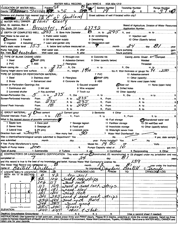
Specific Water Well Detail |
|
|
| Location Info | |||
| Owner: Query, Elmer | Status: Constructed | ||
| Location: T6S, R37W, Sec. 19, SE SE NE | County: Sherman | ||
| Directions: from Goodland, 11 mi N and 12 mi E | |||
| Latitude: 39.5193948 | Longitude: -101.4840022 | Datum NAD 27 | |
| Latitude: 39.5193935 | Longitude: -101.4844457 | Datum NAD 83 | |
| Longitude and latitude calculated by Survey from township-range-section-quarter calls. Only good to within the quarter call accuracy. | |||
| View well on interactive map | |||
| General Info | ||
| Well Depth: 295 ft. | Elevation: ft. | |
| Static Water Level: 155 ft. | Est. Yield: gpm. | |
| Comp. Date: 24-Jul-1981 | Well Use: Domestic | |
| DWR Applic. #: | Other ID: | |
| Driller Info | ||
| Driller: Robert Bartell Drilling & Machine Works | License #: 139 | |
| Scanned Form | View scan |
|
Chemical Sample Submitted?: No
Water Well disinfected?: | ||
| Ground water encountered: 0 ft. , 0 ft. , 0 ft. | ||
| Pump test data: Well water was 0 ft after 0 hours pumping 0 gpm | ||
| Casing Info | ||
| Casing Type:
Casing Joints: |
Diam: 0 in. to 0 ft
Diam: 0 in. to 0 ft Diam: 0 in. to 0 ft | |
| Casing height above land surface: in
Casing Weight: lbs/ft Wall thickness or gauge no.: | ||
| Screen and Perforation Info | ||
| Screen Type: | Screen Openings: | |
| Screen-perforated intervals | From: 5 ft to 295 ft
From: 0 ft to 0 ft From: 0 ft to 0 ft | |
| Gravel pack intervals | From: ft to ft | |
| Grout Info | ||
| Grout used: | From: 0 to 0 ft
From: 0 to 0 ft From: 0 to 0 ft | |
| Source of Possible Contamination | ||
| Source: | ||
| Direction from well: | Distance: 0 ft | |
| Lithologic Log
(Log data entered by KGS.) | ||
| From: 0 ft. to 42 ft. | Top soil | |
| From: 42 ft. to 106 ft. | Sand and clay strips | |
| From: 106 ft. to 117 ft. | Sand rock | |
| From: 117 ft. to 169 ft. | Sand and sand rock strips | |
| From: 169 ft. to 181 ft. | Sand clay | |
| From: 181 ft. to 201 ft. | Sand rock | |
| From: 201 ft. to 232 ft. | Sand and sand rock strips | |
| From: 232 ft. to 244 ft. | Sand rock, hard | |
| From: 244 ft. to 285 ft. | Sand, good | |
| From: 285 ft. to 290 ft. | Gravel | |
| From: 290 ft. to 295 ft. | Ochre and shale | |