|
|
|
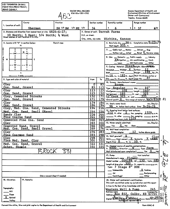
Specific Water Well Detail |
|
|
| Location Info | |||
| Owner: Darrah Farms | Status: Constructed | ||
| Location: T6S, R37W, Sec. 34, SW NW NE | County: Sherman | ||
| Directions: from US 24 and K-27, 10 mi N, 3 mi E, 0.75 mi N, and 0.25 mi W | |||
| Latitude: 39.4942148 | Longitude: -101.4352155 | Datum NAD 27 | |
| Latitude: 39.4942142 | Longitude: -101.435658 | Datum NAD 83 | |
| Longitude and latitude calculated by Survey from township-range-section-quarter calls. Only good to within the quarter call accuracy. | |||
| View well on interactive map | |||
| General Info | ||
| Well Depth: 335 ft. | Elevation: ft. | |
| Static Water Level: 96 ft. | Est. Yield: 1529 gpm. | |
| Comp. Date: 23-Sep-1976 | Well Use: Irrigation | |
| DWR Applic. #: | Other ID: | |
| Links | |
| View info from Wizard Water Level Data base... | |
| View info from WIMAS Water Right Data base... | |
| Driller Info | ||
| Driller: Western Well & Pump, Inc. | License #: 245 | |
| Scanned Form | View scan |
|
Chemical Sample Submitted?: No
Water Well disinfected?: | ||
| Ground water encountered: 0 ft. , 0 ft. , 0 ft. | ||
| Pump test data: Well water was 0 ft after 0 hours pumping 0 gpm | ||
| Casing Info | ||
| Casing Type:
Casing Joints: |
Diam: 0 in. to 0 ft
Diam: 0 in. to 0 ft Diam: 0 in. to 0 ft | |
| Casing height above land surface: in
Casing Weight: lbs/ft Wall thickness or gauge no.: | ||
| Screen and Perforation Info | ||
| Screen Type: | Screen Openings: | |
| Screen-perforated intervals | From: 185 ft to 335 ft
From: 0 ft to 0 ft From: 0 ft to 0 ft | |
| Gravel pack intervals | From: ft to ft | |
| Grout Info | ||
| Grout used: | From: 0 to 0 ft
From: 0 to 0 ft From: 0 to 0 ft | |
| Source of Possible Contamination | ||
| Source: | ||
| Direction from well: | Distance: 0 ft | |
| Lithologic Log
(Log data entered by KGS.) | ||
| From: 0 ft. to 85 ft. | Clay | |
| From: 85 ft. to 115 ft. | Coarse sand, gravel | |
| From: 115 ft. to 125 ft. | Clay | |
| From: 125 ft. to 152 ft. | Coarse sand, gravel | |
| From: 152 ft. to 171 ft. | Clay, cemented streaks | |
| From: 171 ft. to 179 ft. | Coarse sand, gravel | |
| From: 179 ft. to 186 ft. | Clay | |
| From: 186 ft. to 194 ft. | Coarse sand, gravel | |
| From: 194 ft. to 216 ft. | Clay, medium coarse sand, cemented streaks | |
| From: 216 ft. to 226 ft. | Medium coarse sand, small gravel | |
| From: 226 ft. to 244 ft. | Sandy clay | |
| From: 244 ft. to 260 ft. | Fine coarse sand | |
| From: 260 ft. to 263 ft. | Cemented fine coarse sand | |
| From: 263 ft. to 266 ft. | Clay | |
| From: 266 ft. to 269 ft. | Cemented sand and gravel | |
| From: 269 ft. to 276 ft. | Medium coarse sand, small gravel | |
| From: 276 ft. to 283 ft. | Clay | |
| From: 283 ft. to 298 ft. | Fine coarse sand | |
| From: 298 ft. to 301 ft. | Clay | |
| From: 301 ft. to 322 ft. | Fine medium sand, clay | |
| From: 322 ft. to 331 ft. | Medium coarse sand, gravel | |
| From: 331 ft. to 335 ft. | Ochre, shale | |