|
|
|
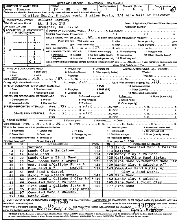
Specific Water Well Detail |
|
|
| Location Info | |||
| Owner: Hartley, Willard | Status: Constructed | ||
| Location: T6S, R38W, Sec. 1, SW SW SE | County: Sherman | ||
| Directions: from Brewster, 10 mi N, 6 mi W, 2 mi N, and 0.75 mi W | |||
| Latitude: 39.5553674 | Longitude: -101.5089792 | Datum NAD 27 | |
| Latitude: 39.5553654 | Longitude: -101.5094233 | Datum NAD 83 | |
| Longitude and latitude calculated by Survey from township-range-section-quarter calls. Only good to within the quarter call accuracy. | |||
| View well on interactive map | |||
| General Info | ||
| Well Depth: 177 ft. | Elevation: ft. | |
| Static Water Level: 62 ft. | Est. Yield: gpm. | |
| Comp. Date: 10-Jun-1993 | Well Use: Domestic | |
| DWR Applic. #: | Other ID: | |
| Driller Info | ||
| Driller: Jay C. Woofter Pump & Well, Inc. | License #: 554 | |
| Scanned Form | View scan |
|
Chemical Sample Submitted?: No
Water Well disinfected?: | ||
| Ground water encountered: 0 ft. , 0 ft. , 0 ft. | ||
| Pump test data: Well water was 0 ft after 0 hours pumping 0 gpm | ||
| Casing Info | ||
| Casing Type: PVC
Casing Joints: |
Diam: 4 in. to 157 ft
Diam: 0 in. to 0 ft Diam: 0 in. to 0 ft | |
| Casing height above land surface: in
Casing Weight: lbs/ft Wall thickness or gauge no.: | ||
| Screen and Perforation Info | ||
| Screen Type: PVC | Screen Openings: Saw cut | |
| Screen-perforated intervals | From: 157 ft to 177 ft
From: 0 ft to 0 ft From: 0 ft to 0 ft | |
| Gravel pack intervals | From: ft to ft | |
| Grout Info | ||
| Grout used: Bentonite | From: 0 to 20 ft
From: 0 to 0 ft From: 0 to 0 ft | |
| Source of Possible Contamination | ||
| Source: Abandoned water well | ||
| Direction from well: | Distance: 0 ft | |
| Lithologic Log
(Log data entered by KGS.) | ||
| From: 0 ft. to 3 ft. | Surface | |
| From: 3 ft. to 10 ft. | Sandy clay and sandstone | |
| From: 10 ft. to 14 ft. | Loose sand | |
| From: 14 ft. to 20 ft. | Sandy clay and tight sand | |
| From: 20 ft. to 30 ft. | Medium loose sand and gravel | |
| From: 30 ft. to 41 ft. | Medium sand with caliche streaks and gravel | |
| From: 41 ft. to 48 ft. | Fine sand and caliche | |
| From: 48 ft. to 51 ft. | Medium sand and gravel | |
| From: 51 ft. to 60 ft. | Sandy clay with sand streaks | |
| From: 60 ft. to 64 ft. | Fine sand and caliche and clay layers | |
| From: 64 ft. to 66 ft. | Cemented sand and caliche | |
| From: 66 ft. to 82 ft. | Fine sand and caliche streaks and clay streaks | |
| From: 82 ft. to 95 ft. | Fine sand and caliche | |
| From: 95 ft. to 97 ft. | Cemented sand and caliche | |
| From: 97 ft. to 104 ft. | Sandy clay | |
| From: 104 ft. to 113 ft. | Sand, cemented sand and caliche | |
| From: 113 ft. to 114 ft. | Caliche | |
| From: 114 ft. to 120 ft. | Sandy clay and caliche | |
| From: 120 ft. to 125 ft. | Caliche with fine sand streaks | |
| From: 125 ft. to 135 ft. | Fine sand with cemented sand streaks | |
| From: 135 ft. to 139 ft. | Sandy clay and caliche with sand streaks | |
| From: 139 ft. to 143 ft. | Cemented sand and clay with clay and sand streaks | |
| From: 143 ft. to 149 ft. | Fine sand | |
| From: 149 ft. to 152 ft. | Sandy clay and caliche | |
| From: 152 ft. to 165 ft. | Fine sand and joint clay | |
| From: 165 ft. to 177 ft. | Fine sand | |