|
|
|
Specific Water Well Detail |
|
|
| Location Info | |||
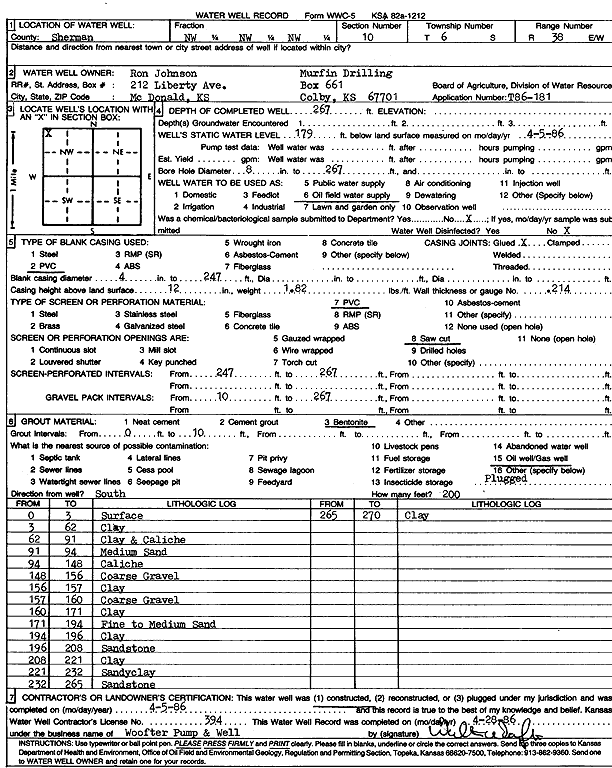
| Owner: Murfin Drilling Co./Ron Johnson | Status: Constructed | ||
| Location: T6S, R38W, Sec. 10, NW NW NW | County: Sherman | ||
| Directions: | |||
| Latitude: 39.553493 | Longitude: -101.5560336 | Datum NAD 27 | |
| Latitude: 39.5534906 | Longitude: -101.556479 | Datum NAD 83 | |
| Longitude and latitude calculated by Survey from township-range-section-quarter calls. Only good to within the quarter call accuracy. | |||
| View well on interactive map | |||
| General Info | ||
| Well Depth: 267 ft. | Elevation: ft. | |
| Static Water Level: 179 ft. | Est. Yield: gpm. | |
| Comp. Date: 05-Apr-1986 | Well Use: Oil Field Water Supply | |
| DWR Applic. #: T86-181 | Other ID: | |
| Driller Info | ||
| Driller: Walter Woofter Pump & Well | License #: 394 | |
| Scanned Form | View scan |
|
Chemical Sample Submitted?: No
Water Well disinfected?: | ||
| Ground water encountered: 0 ft. , 0 ft. , 0 ft. | ||
| Pump test data: Well water was 0 ft after 0 hours pumping 0 gpm | ||
| Casing Info | ||
| Casing Type: PVC
Casing Joints: |
Diam: 4 in. to 247 ft
Diam: 0 in. to 0 ft Diam: 0 in. to 0 ft | |
| Casing height above land surface: in
Casing Weight: lbs/ft Wall thickness or gauge no.: | ||
| Screen and Perforation Info | ||
| Screen Type: PVC | Screen Openings: Saw cut | |
| Screen-perforated intervals | From: 247 ft to 267 ft
From: 0 ft to 0 ft From: 0 ft to 0 ft | |
| Gravel pack intervals | From: ft to ft | |
| Grout Info | ||
| Grout used: Bentonite | From: 0 to 10 ft
From: 0 to 0 ft From: 0 to 0 ft | |
| Source of Possible Contamination | ||
| Source: Oil well/gas well | ||
| Direction from well: | Distance: 0 ft | |
| Lithologic Log
(Log data entered by KGS.) | ||
| From: 0 ft. to 3 ft. | Surface | |
| From: 3 ft. to 62 ft. | Clay | |
| From: 62 ft. to 91 ft. | Clay and caliche | |
| From: 91 ft. to 94 ft. | Medium sand | |
| From: 94 ft. to 148 ft. | Caliche | |
| From: 148 ft. to 156 ft. | Coarse gravel | |
| From: 156 ft. to 157 ft. | Clay | |
| From: 157 ft. to 160 ft. | Coarse gravel | |
| From: 160 ft. to 171 ft. | Clay | |
| From: 171 ft. to 194 ft. | Fine to medium sand | |
| From: 194 ft. to 196 ft. | Clay | |
| From: 196 ft. to 208 ft. | Sandstone | |
| From: 208 ft. to 221 ft. | Clay | |
| From: 221 ft. to 232 ft. | Sandy clay | |
| From: 232 ft. to 265 ft. | Sandstone | |
| From: 265 ft. to 270 ft. | Clay | |