|
|
|
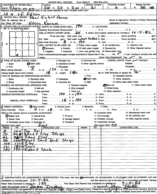
Specific Water Well Detail |
|
|
| Location Info | |||
| Owner: Paul Kuhrt Farms | Status: Constructed | ||
| Location: T6S, R38W, Sec. 21, SW SE SW | County: Sherman | ||
| Directions: from Edson, 12 mi N | |||
| Latitude: 39.5119209 | Longitude: -101.5706185 | Datum NAD 27 | |
| Latitude: 39.5119188 | Longitude: -101.5710646 | Datum NAD 83 | |
| Longitude and latitude calculated by Survey from township-range-section-quarter calls. Only good to within the quarter call accuracy. | |||
| View well on interactive map | |||
| General Info | ||
| Well Depth: 190 ft. | Elevation: ft. | |
| Static Water Level: 25 ft. | Est. Yield: gpm. | |
| Comp. Date: 07-Oct-1982 | Well Use: Domestic | |
| DWR Applic. #: | Other ID: | |
| Driller Info | ||
| Driller: Robert Bartell Drilling & Machine Works | License #: 139 | |
| Scanned Form | View scan |
|
Chemical Sample Submitted?: No
Water Well disinfected?: | ||
| Ground water encountered: 0 ft. , 0 ft. , 0 ft. | ||
| Pump test data: Well water was 0 ft after 0 hours pumping 0 gpm | ||
| Casing Info | ||
| Casing Type:
Casing Joints: |
Diam: 0 in. to 0 ft
Diam: 0 in. to 0 ft Diam: 0 in. to 0 ft | |
| Casing height above land surface: in
Casing Weight: lbs/ft Wall thickness or gauge no.: | ||
| Screen and Perforation Info | ||
| Screen Type: | Screen Openings: | |
| Screen-perforated intervals | From: 170 ft to 190 ft
From: 0 ft to 0 ft From: 0 ft to 0 ft | |
| Gravel pack intervals | From: ft to ft | |
| Grout Info | ||
| Grout used: | From: 0 to 0 ft
From: 0 to 0 ft From: 0 to 0 ft | |
| Source of Possible Contamination | ||
| Source: | ||
| Direction from well: | Distance: 0 ft | |
| Lithologic Log
(Log data entered by KGS.) | ||
| From: 0 ft. to 10 ft. | Top soil | |
| From: 10 ft. to 42 ft. | Sand and clay strips | |
| From: 42 ft. to 56 ft. | Sand clay | |
| From: 56 ft. to 166 ft. | Sand and sand rock strips | |
| From: 166 ft. to 171 ft. | Clay | |
| From: 171 ft. to 187 ft. | Sand | |
| From: 187 ft. to 190 ft. | Ochre and shale | |