|
|
|
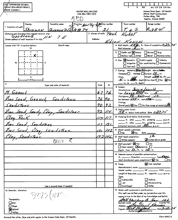
Specific Water Well Detail |
|
|
| Location Info | |||
| Owner: Kuhrt, Paul | Status: Constructed | ||
| Location: T6S, R38W, Sec. 21, SE NW NE | County: Sherman | ||
| Directions: from Goodland, 11 mi N and 7 mi E | |||
| Latitude: 39.5227996 | Longitude: -101.5634817 | Datum NAD 27 | |
| Latitude: 39.5227975 | Longitude: -101.5639275 | Datum NAD 83 | |
| Longitude and latitude calculated by Survey from township-range-section-quarter calls. Only good to within the quarter call accuracy. | |||
| View well on interactive map | |||
| General Info | ||
| Well Depth: 146 ft. | Elevation: ft. | |
| Static Water Level: 58 ft. | Est. Yield: 50 gpm. | |
| Comp. Date: 27-Jan-1975 | Well Use: Domestic | |
| DWR Applic. #: | Other ID: | |
| Driller Info | ||
| Driller: S & H Drilling Co., Inc. | License #: 166 | |
| Scanned Form | View scan |
|
Chemical Sample Submitted?: No
Water Well disinfected?: | ||
| Ground water encountered: 0 ft. , 0 ft. , 0 ft. | ||
| Pump test data: Well water was 0 ft after 0 hours pumping 0 gpm | ||
| Casing Info | ||
| Casing Type:
Casing Joints: |
Diam: 0 in. to 0 ft
Diam: 0 in. to 0 ft Diam: 0 in. to 0 ft | |
| Casing height above land surface: in
Casing Weight: lbs/ft Wall thickness or gauge no.: | ||
| Screen and Perforation Info | ||
| Screen Type: | Screen Openings: | |
| Screen-perforated intervals | From: 134 ft to 146 ft
From: 0 ft to 0 ft From: 0 ft to 0 ft | |
| Gravel pack intervals | From: ft to ft | |
| Grout Info | ||
| Grout used: | From: 0 to 0 ft
From: 0 to 0 ft From: 0 to 0 ft | |
| Source of Possible Contamination | ||
| Source: | ||
| Direction from well: | Distance: 0 ft | |
| Lithologic Log
(Log data entered by KGS.) | ||
| From: 67 ft. to 76 ft. | Medium gravel | |
| From: 76 ft. to 90 ft. | Fine sand, gravel, sandstone | |
| From: 90 ft. to 92 ft. | Sandstone | |
| From: 92 ft. to 114 ft. | Fine sand, sandy clay, sandstone | |
| From: 114 ft. to 117 ft. | Clay rock | |
| From: 117 ft. to 121 ft. | Fine sand, sandstone | |
| From: 121 ft. to 142 ft. | Fine sand, clay, sandstone | |
| From: 142 ft. to 146 ft. | Clay, sandstone | |