|
|
|
Specific Water Well Detail |
|
|
| Location Info | |||
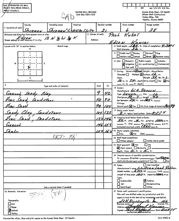
| Owner: Kuhrt, Paul | Status: Constructed | ||
| Location: T6S, R38W, Sec. 21, SE NE SW | County: Sherman | ||
| Directions: from Goodland, 12 mi N, 0.5 mi W, and 0.25 mi N | |||
| Latitude: 39.515551 | Longitude: -101.5682443 | Datum NAD 27 | |
| Latitude: 39.5155489 | Longitude: -101.5686903 | Datum NAD 83 | |
| Longitude and latitude calculated by Survey from township-range-section-quarter calls. Only good to within the quarter call accuracy. | |||
| View well on interactive map | |||
| General Info | ||
| Well Depth: 164 ft. | Elevation: ft. | |
| Static Water Level: 8 ft. | Est. Yield: 1800 gpm. | |
| Comp. Date: 30-Apr-1975 | Well Use: Irrigation | |
| DWR Applic. #: | Other ID: | |
| Links | |
| View info from Wizard Water Level Data base... | |
| View info from WIMAS Water Right Data base... | |
| Driller Info | ||
| Driller: S & H Drilling Co., Inc. | License #: 166 | |
| Scanned Form | View scan |
|
Chemical Sample Submitted?: No
Water Well disinfected?: | ||
| Ground water encountered: 0 ft. , 0 ft. , 0 ft. | ||
| Pump test data: Well water was 0 ft after 0 hours pumping 0 gpm | ||
| Casing Info | ||
| Casing Type:
Casing Joints: |
Diam: 0 in. to 0 ft
Diam: 0 in. to 0 ft Diam: 0 in. to 0 ft | |
| Casing height above land surface: in
Casing Weight: lbs/ft Wall thickness or gauge no.: | ||
| Screen and Perforation Info | ||
| Screen Type: | Screen Openings: | |
| Screen-perforated intervals | From: 74 ft to 164 ft
From: 0 ft to 0 ft From: 0 ft to 0 ft | |
| Gravel pack intervals | From: ft to ft | |
| Grout Info | ||
| Grout used: | From: 0 to 0 ft
From: 0 to 0 ft From: 0 to 0 ft | |
| Source of Possible Contamination | ||
| Source: | ||
| Direction from well: | Distance: 0 ft | |
| Lithologic Log
(Log data entered by KGS.) | ||
| From: 9 ft. to 40 ft. | Gravel, sandy clay | |
| From: 40 ft. to 90 ft. | Fine sand, sandstone | |
| From: 90 ft. to 104 ft. | Fine sand | |
| From: 104 ft. to 133 ft. | Sandy clay, sandstone | |
| From: 133 ft. to 146 ft. | Fine sand, sandstone | |
| From: 146 ft. to 159 ft. | Gravel | |
| From: 159 ft. to 164 ft. | Shale | |