|
|
|
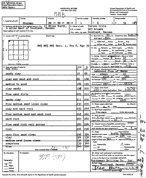
Specific Water Well Detail |
|
|
| Location Info | |||
| Owner: Irvin, Vernon | Status: Constructed | ||
| Location: T6S, R39W, Sec. 1, NW NW NW | County: Sherman | ||
| Directions: from Goodland, 15 mi N and 4 mi E | |||
| Latitude: 39.5675983 | Longitude: -101.6304811 | Datum NAD 27 | |
| Latitude: 39.5675949 | Longitude: -101.6309288 | Datum NAD 83 | |
| Longitude and latitude calculated by Survey from township-range-section-quarter calls. Only good to within the quarter call accuracy. | |||
| View well on interactive map | |||
| General Info | ||
| Well Depth: 350 ft. | Elevation: ft. | |
| Static Water Level: 153 ft. | Est. Yield: 1200 gpm. | |
| Comp. Date: 21-Mar-1976 | Well Use: Irrigation | |
| DWR Applic. #: | Other ID: | |
| Links | |
| View info from Wizard Water Level Data base... | |
| View info from WIMAS Water Right Data base... | |
| Driller Info | ||
| Driller: Northwest Drilling Co., Inc. | License #: 248 | |
| Scanned Form | View scan |
|
Chemical Sample Submitted?: No
Water Well disinfected?: | ||
| Ground water encountered: 0 ft. , 0 ft. , 0 ft. | ||
| Pump test data: Well water was 0 ft after 0 hours pumping 0 gpm | ||
| Casing Info | ||
| Casing Type:
Casing Joints: |
Diam: 0 in. to 0 ft
Diam: 0 in. to 0 ft Diam: 0 in. to 0 ft | |
| Casing height above land surface: in
Casing Weight: lbs/ft Wall thickness or gauge no.: | ||
| Screen and Perforation Info | ||
| Screen Type: | Screen Openings: | |
| Screen-perforated intervals | From: 190 ft to 350 ft
From: 0 ft to 0 ft From: 0 ft to 0 ft | |
| Gravel pack intervals | From: ft to ft | |
| Grout Info | ||
| Grout used: | From: 0 to 0 ft
From: 0 to 0 ft From: 0 to 0 ft | |
| Source of Possible Contamination | ||
| Source: | ||
| Direction from well: | Distance: 0 ft | |
| Lithologic Log
(Log data entered by KGS.) | ||
| From: 0 ft. to 16 ft. | Top soil | |
| From: 16 ft. to 66 ft. | Sandy clay | |
| From: 66 ft. to 186 ft. | Clay and sand and rock | |
| From: 186 ft. to 195 ft. | Medium to good | |
| From: 195 ft. to 205 ft. | Clay, sandy | |
| From: 205 ft. to 211 ft. | Fine sand, dirty | |
| From: 211 ft. to 230 ft. | Sandy clay | |
| From: 230 ft. to 235 ft. | Fine medium sand, loose, clean | |
| From: 235 ft. to 248 ft. | Clay and hard rock | |
| From: 248 ft. to 260 ft. | Fine medium sand and sand rock | |
| From: 260 ft. to 280 ft. | Hard rock | |
| From: 280 ft. to 294 ft. | Fine sand rock, very porous | |
| From: 294 ft. to 296 ft. | Rock | |
| From: 296 ft. to 324 ft. | Very fine sand, clean | |
| From: 324 ft. to 336 ft. | Clay | |
| From: 336 ft. to 339 ft. | Medium sand, loose, clean | |
| From: 339 ft. to 346 ft. | Soapstone | |
| From: 346 ft. to 350 ft. | Blue | |