|
|
|
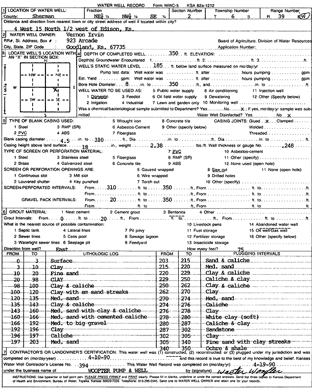
Specific Water Well Detail |
|
|
| Location Info | |||
| Owner: Irvin, Vernon | Status: Constructed | ||
| Location: T6S, R39W, Sec. 2, NE NW SE | County: Sherman | ||
| Directions: From Edson, 4 miles West, 15 miles North, and .5 mile West | |||
| Latitude: 39.5604325 | Longitude: -101.6374347 | Datum NAD 27 | |
| Latitude: 39.5604291 | Longitude: -101.6378826 | Datum NAD 83 | |
| Longitude and latitude calculated by Survey from township-range-section-quarter calls. Only good to within the quarter call accuracy. | |||
| View well on interactive map | |||
| General Info | ||
| Well Depth: 350 ft. | Elevation: ft. | |
| Static Water Level: 185 ft. | Est. Yield: gpm. | |
| Comp. Date: 10-Apr-1990 | Well Use: Domestic | |
| DWR Applic. #: | Other ID: | |
| Driller Info | ||
| Driller: Walter Woofter Pump & Well | License #: 394 | |
| Scanned Form | View scan |
|
Chemical Sample Submitted?: No
Water Well disinfected?: | ||
| Ground water encountered: 0 ft. , 0 ft. , 0 ft. | ||
| Pump test data: Well water was 0 ft after 0 hours pumping 0 gpm | ||
| Casing Info | ||
| Casing Type: PVC
Casing Joints: |
Diam: 4 in. to 310 ft
Diam: 0 in. to 0 ft Diam: 0 in. to 0 ft | |
| Casing height above land surface: in
Casing Weight: lbs/ft Wall thickness or gauge no.: | ||
| Screen and Perforation Info | ||
| Screen Type: PVC | Screen Openings: Saw cut | |
| Screen-perforated intervals | From: 310 ft to 350 ft
From: 0 ft to 0 ft From: 0 ft to 0 ft | |
| Gravel pack intervals | From: ft to ft | |
| Grout Info | ||
| Grout used: Bentonite | From: 0 to 20 ft
From: 0 to 0 ft From: 0 to 0 ft | |
| Source of Possible Contamination | ||
| Source: Abandoned water well | ||
| Direction from well: | Distance: 0 ft | |
| Lithologic Log
(Log data entered by KGS.) | ||
| From: 0 ft. to 3 ft. | Surface | |
| From: 3 ft. to 10 ft. | Clay | |
| From: 10 ft. to 20 ft. | Fine sand | |
| From: 20 ft. to 98 ft. | Clay | |
| From: 98 ft. to 100 ft. | Clay and caliche | |
| From: 100 ft. to 120 ft. | Clay with small sand streaks | |
| From: 120 ft. to 135 ft. | Medium sand | |
| From: 135 ft. to 143 ft. | Clay and caliche | |
| From: 143 ft. to 160 ft. | Medium sand with clay and caliche | |
| From: 160 ft. to 166 ft. | Medium sand with cemented caliche | |
| From: 166 ft. to 192 ft. | Medium to big gravel | |
| From: 192 ft. to 196 ft. | Clay | |
| From: 196 ft. to 197 ft. | Caliche | |
| From: 197 ft. to 203 ft. | Medium sand | |
| From: 203 ft. to 215 ft. | Sand and caliche | |
| From: 215 ft. to 220 ft. | Medium sand | |
| From: 220 ft. to 229 ft. | Clay and caliche | |
| From: 229 ft. to 250 ft. | Caliche and clay | |
| From: 250 ft. to 262 ft. | Clay and caliche | |
| From: 262 ft. to 270 ft. | Clay | |
| From: 270 ft. to 274 ft. | Medium sand | |
| From: 274 ft. to 276 ft. | Caliche | |
| From: 276 ft. to 278 ft. | Clay | |
| From: 278 ft. to 280 ft. | White clay, soft | |
| From: 280 ft. to 287 ft. | Caliche and clay | |
| From: 287 ft. to 302 ft. | Sandstone | |
| From: 302 ft. to 305 ft. | Clay | |
| From: 305 ft. to 340 ft. | Fine sand with clay streaks | |
| From: 340 ft. to 350 ft. | Ochre and shale | |