|
|
|
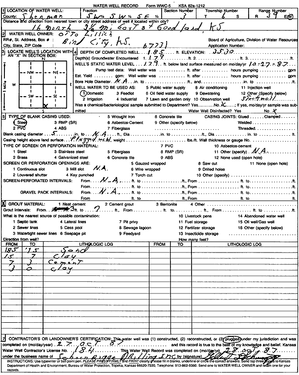
Specific Water Well Detail |
|
|
| Location Info | |||
| Owner: Lillich, Otto | Status: Plugged | ||
| Location: T6S, R39W, Sec. 3, SW SW SE | County: Sherman | ||
| Directions: From Goodland, 16 miles North and 3.5 miles East | |||
| Latitude: 39.5549739 | Longitude: -101.6584587 | Datum NAD 27 | |
| Latitude: 39.5549704 | Longitude: -101.6589073 | Datum NAD 83 | |
| Longitude and latitude calculated by Survey from township-range-section-quarter calls. Only good to within the quarter call accuracy. | |||
| View well on interactive map | |||
| General Info | ||
| Well Depth: 185 ft. | Elevation: 3530 ft. | |
| Static Water Level: 179 ft. | Est. Yield: gpm. | |
| Comp. Date: 27-Oct-1987 | Well Use: Domestic | |
| DWR Applic. #: | Other ID: | |
| Driller Info | ||
| Driller: Schoenrogge Drilling, Inc. | License #: 184 | |
| Scanned Form | View scan |
| Casing Info | ||
|
Casing Type: Steel
Diam: 5 in. Casing height above land surface: in | ||
| Grout Info | ||
| Grout used: | From: 3 to 7 ft
From: 0 to 0 ft From: 0 to 0 ft | |
| Source of Possible Contamination | ||
| Source: | ||
| Direction from well: | Distance: 0 ft | |