|
|
|
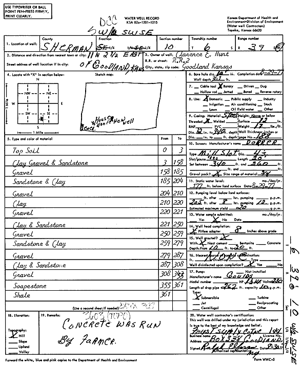
Specific Water Well Detail |
|
|
| Location Info | |||
| Owner: Hunt, Clarence | Status: Constructed | ||
| Location: T6S, R39W, Sec. 10, SW SW SE | County: Sherman | ||
| Directions: From Goodland, 11 miles North and 2.5 miles East | |||
| Latitude: 39.5405462 | Longitude: -101.6585938 | Datum NAD 27 | |
| Latitude: 39.5405429 | Longitude: -101.6590423 | Datum NAD 83 | |
| Longitude and latitude calculated by Survey from township-range-section-quarter calls. Only good to within the quarter call accuracy. | |||
| View well on interactive map | |||
| General Info | ||
| Well Depth: 361 ft. | Elevation: ft. | |
| Static Water Level: 177 ft. | Est. Yield: 20 gpm. | |
| Comp. Date: 29-Aug-1977 | Well Use: Domestic | |
| DWR Applic. #: | Other ID: | |
| Driller Info | ||
| Driller: A.J. Foust Supply Co. Inc. | License #: 144 | |
| Scanned Form | View scan |
|
Chemical Sample Submitted?: No
Water Well disinfected?: | ||
| Ground water encountered: 0 ft. , 0 ft. , 0 ft. | ||
| Pump test data: Well water was 0 ft after 0 hours pumping 0 gpm | ||
| Casing Info | ||
| Casing Type:
Casing Joints: |
Diam: 0 in. to 0 ft
Diam: 0 in. to 0 ft Diam: 0 in. to 0 ft | |
| Casing height above land surface: in
Casing Weight: lbs/ft Wall thickness or gauge no.: | ||
| Screen and Perforation Info | ||
| Screen Type: | Screen Openings: | |
| Screen-perforated intervals | From: 340 ft to 360 ft
From: 0 ft to 0 ft From: 0 ft to 0 ft | |
| Gravel pack intervals | From: ft to ft | |
| Grout Info | ||
| Grout used: | From: 0 to 0 ft
From: 0 to 0 ft From: 0 to 0 ft | |
| Source of Possible Contamination | ||
| Source: | ||
| Direction from well: | Distance: 0 ft | |
| Lithologic Log
(Log data entered by KGS.) | ||
| From: 0 ft. to 3 ft. | Top soil | |
| From: 3 ft. to 158 ft. | Clay, gravel, sand sandstone | |
| From: 158 ft. to 185 ft. | Gravel | |
| From: 185 ft. to 204 ft. | Sandstone and clay | |
| From: 204 ft. to 210 ft. | Gravel | |
| From: 210 ft. to 220 ft. | Clay | |
| From: 220 ft. to 221 ft. | Gravel | |
| From: 221 ft. to 250 ft. | Clay and sandstone | |
| From: 250 ft. to 259 ft. | Gravel | |
| From: 259 ft. to 279 ft. | Sandstone and clay | |
| From: 279 ft. to 287 ft. | Gravel | |
| From: 287 ft. to 308 ft. | Clay and sandstone | |
| From: 308 ft. to 355 ft. | Gravel | |
| From: 355 ft. to 361 ft. | Soapstone | |
| From: 361 ft. to ft. | Shale | |