|
|
|
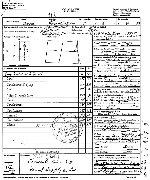
Specific Water Well Detail |
|
|
| Location Info | |||
| Owner: Deeds, John | Status: Constructed | ||
| Location: T6S, R39W, Sec. 17, SE SE NE | County: Sherman | ||
| Directions: From Goodland, 11 miles North, 2 miles East, and .5 mile North | |||
| Latitude: 39.5332739 | Longitude: -101.6891019 | Datum NAD 27 | |
| Latitude: 39.5332703 | Longitude: -101.6895514 | Datum NAD 83 | |
| Longitude and latitude calculated by Survey from township-range-section-quarter calls. Only good to within the quarter call accuracy. | |||
| View well on interactive map | |||
| General Info | ||
| Well Depth: 324 ft. | Elevation: ft. | |
| Static Water Level: 177 ft. | Est. Yield: 955 gpm. | |
| Comp. Date: 26-Feb-1977 | Well Use: Irrigation | |
| DWR Applic. #: | Other ID: | |
| Links | |
| View info from Wizard Water Level Data base... | |
| View info from WIMAS Water Right Data base... | |
| Driller Info | ||
| Driller: A.J. Foust Supply Co. Inc. | License #: 144 | |
| Scanned Form | View scan |
|
Chemical Sample Submitted?: No
Water Well disinfected?: | ||
| Ground water encountered: 0 ft. , 0 ft. , 0 ft. | ||
| Pump test data: Well water was 0 ft after 0 hours pumping 0 gpm | ||
| Casing Info | ||
| Casing Type:
Casing Joints: |
Diam: 0 in. to 0 ft
Diam: 0 in. to 0 ft Diam: 0 in. to 0 ft | |
| Casing height above land surface: in
Casing Weight: lbs/ft Wall thickness or gauge no.: | ||
| Screen and Perforation Info | ||
| Screen Type: | Screen Openings: | |
| Screen-perforated intervals | From: 184 ft to 324 ft
From: 0 ft to 0 ft From: 0 ft to 0 ft | |
| Gravel pack intervals | From: ft to ft | |
| Grout Info | ||
| Grout used: | From: 0 to 0 ft
From: 0 to 0 ft From: 0 to 0 ft | |
| Source of Possible Contamination | ||
| Source: | ||
| Direction from well: | Distance: 0 ft | |
| Lithologic Log
(Log data entered by KGS.) | ||
| From: 0 ft. to 177 ft. | Clay, sandstone, and gravel | |
| From: 177 ft. to 184 ft. | Sand | |
| From: 184 ft. to 216 ft. | Sandstone and clay | |
| From: 216 ft. to 220 ft. | Sand | |
| From: 220 ft. to 236 ft. | Clay and sandstone | |
| From: 236 ft. to 239 ft. | Sand | |
| From: 239 ft. to 257 ft. | Sandstone | |
| From: 257 ft. to 313 ft. | Sandy clay | |
| From: 313 ft. to 320 ft. | Gravel | |
| From: 320 ft. to 325 ft. | Soapstone | |
| From: 325 ft. to 331 ft. | Shale | |