|
|
|
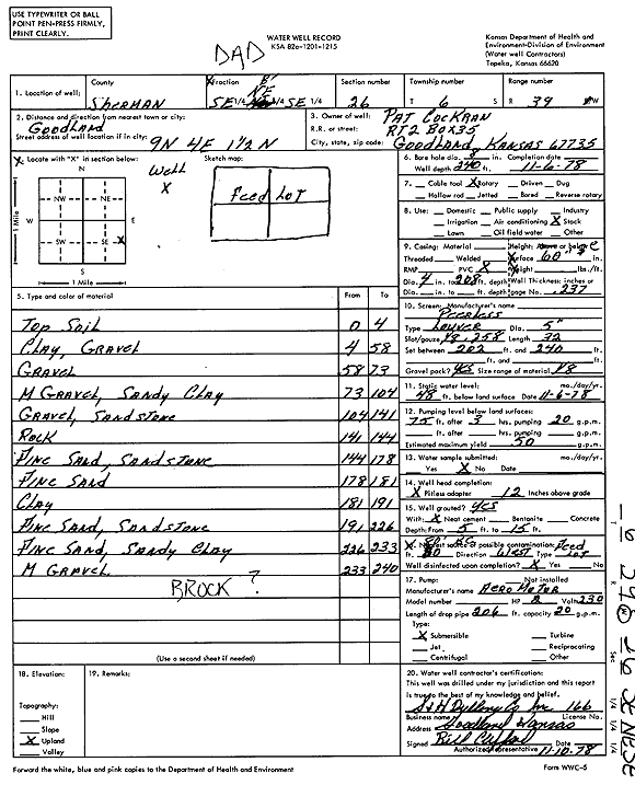
Specific Water Well Detail |
|
|
| Location Info | |||
| Owner: Cochran, Pat | Status: Constructed | ||
| Location: T6S, R39W, Sec. 26, SE NE SE | County: Sherman | ||
| Directions: From Goodland, 9 miles North, 4 miles East, and 1.5 miles North | |||
| Latitude: 39.5006459 | Longitude: -101.6330611 | Datum NAD 27 | |
| Latitude: 39.5006434 | Longitude: -101.633509 | Datum NAD 83 | |
| Longitude and latitude calculated by Survey from township-range-section-quarter calls. Only good to within the quarter call accuracy. | |||
| View well on interactive map | |||
| General Info | ||
| Well Depth: 240 ft. | Elevation: ft. | |
| Static Water Level: 48 ft. | Est. Yield: 50 gpm. | |
| Comp. Date: 06-Nov-1978 | Well Use: Domestic, Livestock | |
| DWR Applic. #: | Other ID: | |
| Driller Info | ||
| Driller: C. Struckhoff, S&H Drilling Co.,Inc. | License #: 166 | |
| Scanned Form | View scan |
|
Chemical Sample Submitted?: No
Water Well disinfected?: | ||
| Ground water encountered: 0 ft. , 0 ft. , 0 ft. | ||
| Pump test data: Well water was 0 ft after 0 hours pumping 0 gpm | ||
| Casing Info | ||
| Casing Type:
Casing Joints: |
Diam: 0 in. to 0 ft
Diam: 0 in. to 0 ft Diam: 0 in. to 0 ft | |
| Casing height above land surface: in
Casing Weight: lbs/ft Wall thickness or gauge no.: | ||
| Screen and Perforation Info | ||
| Screen Type: | Screen Openings: | |
| Screen-perforated intervals | From: 202 ft to 240 ft
From: 0 ft to 0 ft From: 0 ft to 0 ft | |
| Gravel pack intervals | From: ft to ft | |
| Grout Info | ||
| Grout used: | From: 0 to 0 ft
From: 0 to 0 ft From: 0 to 0 ft | |
| Source of Possible Contamination | ||
| Source: | ||
| Direction from well: | Distance: 0 ft | |
| Lithologic Log
(Log data entered by KGS.) | ||
| From: 0 ft. to 4 ft. | Top soil | |
| From: 4 ft. to 58 ft. | Clay, gravel | |
| From: 58 ft. to 73 ft. | Gravel | |
| From: 73 ft. to 104 ft. | Medium gravel, sandy clay | |
| From: 104 ft. to 141 ft. | Gravel, sandstone | |
| From: 141 ft. to 144 ft. | Rock | |
| From: 144 ft. to 178 ft. | Fine sand, sandstone | |
| From: 178 ft. to 181 ft. | Fine sand | |
| From: 181 ft. to 191 ft. | Clay | |
| From: 191 ft. to 226 ft. | Fine sand, sandstone | |
| From: 226 ft. to 233 ft. | Fine sand, sandy clay | |
| From: 233 ft. to 240 ft. | Medium gravel | |