|
|
|
Specific Water Well Detail |
|
|
| Location Info | |||
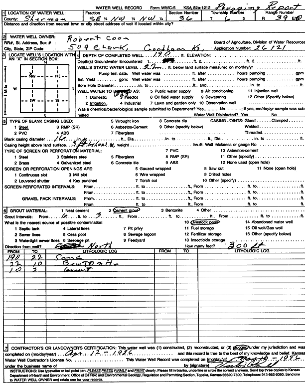
| Owner: Coon, Robert | Status: Plugged | ||
| Location: T6S, R39W, Sec. 36, SE NW NW | County: Sherman | ||
| Directions: | |||
| Latitude: 39.493385 | Longitude: -101.6284103 | Datum NAD 27 | |
| Latitude: 39.4933826 | Longitude: -101.6288581 | Datum NAD 83 | |
| Longitude and latitude calculated by Survey from township-range-section-quarter calls. Only good to within the quarter call accuracy. | |||
| View well on interactive map | |||
| General Info | ||
| Well Depth: 190 ft. | Elevation: ft. | |
| Static Water Level: 22 ft. | Est. Yield: gpm. | |
| Comp. Date: 12-Apr-1986 | Well Use: Irrigation | |
| DWR Applic. #: 26121 | Other ID: | |
| Links | |
| View info from Wizard Water Level Data base... | |
| View info from WIMAS Water Right Data base... | |
| Driller Info | ||
| Driller: unknown | License #: | |
| Scanned Form | View scan |
| Casing Info | ||
|
Casing Type: Steel
Diam: 16 in. Casing height above land surface: in | ||
| Grout Info | ||
| Grout used: Cement grout | From: 6 to 3 ft
From: 0 to 0 ft From: 0 to 0 ft | |
| Source of Possible Contamination | ||
| Source: Livestock pens | ||
| Direction from well: | Distance: 0 ft | |