|
|
|
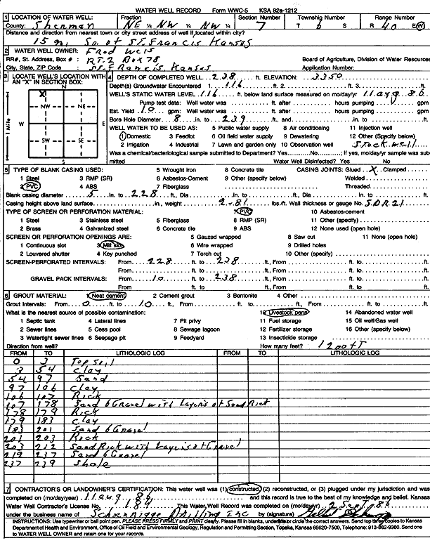
Specific Water Well Detail |
|
|
| Location Info | |||
| Owner: Weis, Fred | Status: Constructed | ||
| Location: T6S, R40W, Sec. 7, NE NW NW | County: Sherman | ||
| Directions: From St. Francis, 15 miles South | |||
| Latitude: 39.5529766 | Longitude: -101.8318117 | Datum NAD 27 | |
| Latitude: 39.5529719 | Longitude: -101.8322657 | Datum NAD 83 | |
| Longitude and latitude calculated by Survey from township-range-section-quarter calls. Only good to within the quarter call accuracy. | |||
| View well on interactive map | |||
| General Info | ||
| Well Depth: 238 ft. | Elevation: 3350 ft. | |
| Static Water Level: 116 ft. | Est. Yield: 10 gpm. | |
| Comp. Date: 11-Aug-1986 | Well Use: Domestic | |
| DWR Applic. #: | Other ID: | |
| Driller Info | ||
| Driller: Schoenrogge Drilling, Inc. | License #: 184 | |
| Scanned Form | View scan |
|
Chemical Sample Submitted?:
Water Well disinfected?: | ||
| Ground water encountered: 116 ft. , 0 ft. , 0 ft. | ||
| Pump test data: Well water was 0 ft after 0 hours pumping 0 gpm | ||
| Casing Info | ||
| Casing Type: PVC
Casing Joints: |
Diam: 5 in. to 228 ft
Diam: 0 in. to 0 ft Diam: 0 in. to 0 ft | |
| Casing height above land surface: in
Casing Weight: lbs/ft Wall thickness or gauge no.: | ||
| Screen and Perforation Info | ||
| Screen Type: PVC | Screen Openings: Mill slot | |
| Screen-perforated intervals | From: 228 ft to 238 ft
From: 0 ft to 0 ft From: 0 ft to 0 ft | |
| Gravel pack intervals | From: ft to ft | |
| Grout Info | ||
| Grout used: Neat cement | From: 0 to 10 ft
From: 0 to 0 ft From: 0 to 0 ft | |
| Source of Possible Contamination | ||
| Source: Livestock pens | ||
| Direction from well: | Distance: 0 ft | |
| Lithologic Log
(Log data entered by KGS.) | ||
| From: 0 ft. to 3 ft. | Top soil | |
| From: 3 ft. to 54 ft. | Clay | |
| From: 54 ft. to 97 ft. | Sand | |
| From: 97 ft. to 106 ft. | Clay | |
| From: 106 ft. to 107 ft. | Rock | |
| From: 107 ft. to 178 ft. | Sand and gravel with layers of sand rock | |
| From: 178 ft. to 179 ft. | Rock | |
| From: 179 ft. to 183 ft. | Clay | |
| From: 183 ft. to 201 ft. | Sand and gravel | |
| From: 201 ft. to 203 ft. | Rock | |
| From: 203 ft. to 212 ft. | Sand rock with layers of gravel | |
| From: 212 ft. to 237 ft. | Sand and gravel | |
| From: 237 ft. to 239 ft. | Shale | |