|
|
|
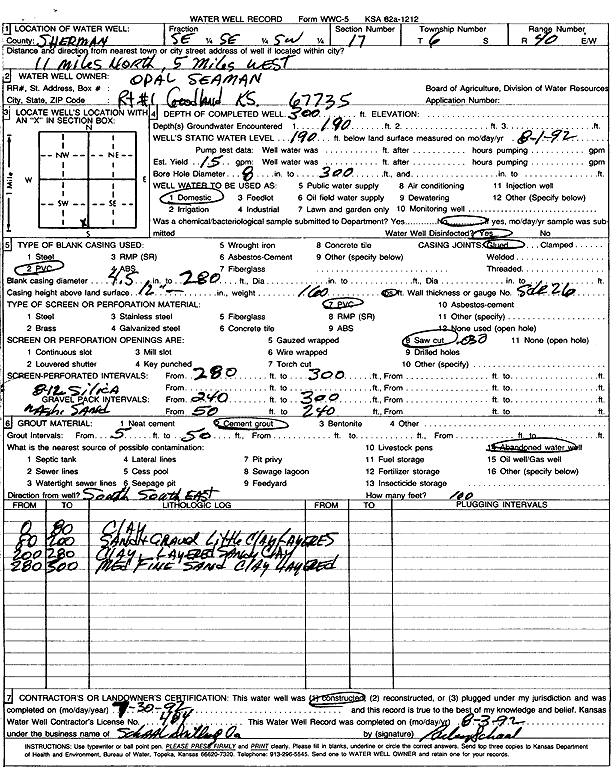
Specific Water Well Detail |
|
|
| Location Info | |||
| Owner: Seaman, Opal | Status: Constructed | ||
| Location: T6S, R40W, Sec. 17, SE SE SW | County: Sherman | ||
| Directions: From Goodland, 11 miles North and 5 miles West | |||
| Latitude: 39.5258878 | Longitude: -101.8096785 | Datum NAD 27 | |
| Latitude: 39.5258835 | Longitude: -101.8101318 | Datum NAD 83 | |
| Longitude and latitude calculated by Survey from township-range-section-quarter calls. Only good to within the quarter call accuracy. | |||
| View well on interactive map | |||
| General Info | ||
| Well Depth: 300 ft. | Elevation: ft. | |
| Static Water Level: 190 ft. | Est. Yield: 15 gpm. | |
| Comp. Date: 30-Jul-1992 | Well Use: Domestic | |
| DWR Applic. #: | Other ID: | |
| Driller Info | ||
| Driller: Ruben T. Schaal Drilling Co. | License #: 484 | |
| Scanned Form | View scan |
|
Chemical Sample Submitted?: No
Water Well disinfected?: | ||
| Ground water encountered: 190 ft. , 0 ft. , 0 ft. | ||
| Pump test data: Well water was 0 ft after 0 hours pumping 0 gpm | ||
| Casing Info | ||
| Casing Type: PVC
Casing Joints: |
Diam: 4 in. to 280 ft
Diam: 0 in. to 0 ft Diam: 0 in. to 0 ft | |
| Casing height above land surface: in
Casing Weight: lbs/ft Wall thickness or gauge no.: | ||
| Screen and Perforation Info | ||
| Screen Type: PVC | Screen Openings: Saw cut | |
| Screen-perforated intervals | From: 280 ft to 300 ft
From: 0 ft to 0 ft From: 0 ft to 0 ft | |
| Gravel pack intervals | From: ft to ft | |
| Grout Info | ||
| Grout used: Cement grout | From: 5 to 50 ft
From: 0 to 0 ft From: 0 to 0 ft | |
| Source of Possible Contamination | ||
| Source: Abandoned water well | ||
| Direction from well: | Distance: 0 ft | |
| Lithologic Log
(Log data entered by KGS.) | ||
| From: 0 ft. to 80 ft. | Clay | |
| From: 80 ft. to 200 ft. | Sand and gravel, little clay layers | |
| From: 200 ft. to 280 ft. | Clay, layers sandy clay | |
| From: 280 ft. to 300 ft. | Medium fine sand, clay layers | |