|
|
|
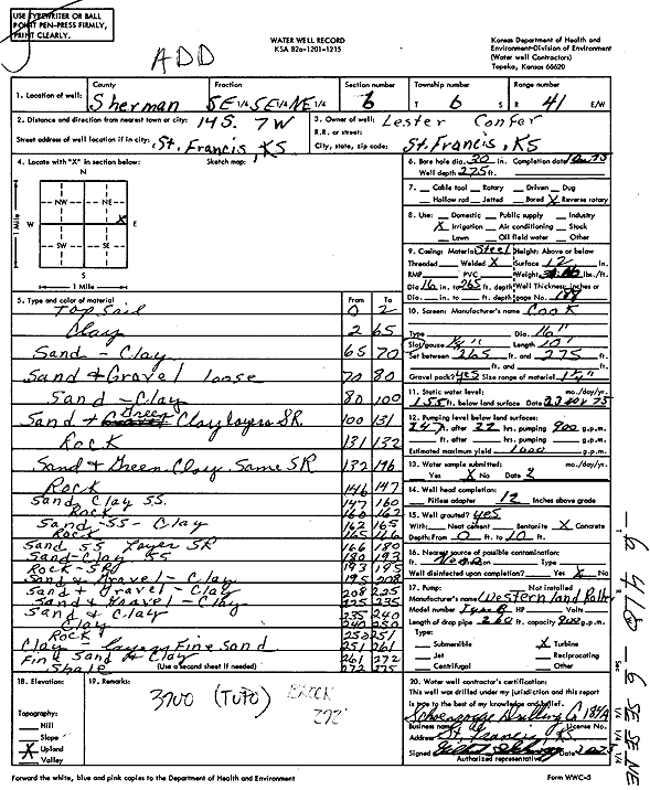
Specific Water Well Detail |
|
|
| Location Info | |||
| Owner: Confer, Lester | Status: Constructed | ||
| Location: T6S, R41W, Sec. 6, SE SE NE | County: Sherman | ||
| Directions: from St. Francis, 14 mi S and 7 mi W | |||
| Latitude: 39.561995 | Longitude: -101.9296746 | Datum NAD 27 | |
| Latitude: 39.56199 | Longitude: -101.9301321 | Datum NAD 83 | |
| Longitude and latitude calculated by Survey from township-range-section-quarter calls. Only good to within the quarter call accuracy. | |||
| View well on interactive map | |||
| General Info | ||
| Well Depth: 275 ft. | Elevation: ft. | |
| Static Water Level: 155 ft. | Est. Yield: 1000 gpm. | |
| Comp. Date: 01-Oct-1975 | Well Use: Irrigation | |
| DWR Applic. #: | Other ID: | |
| Links | |
| No Wizard information available. | |
| View info from WIMAS Water Right Data base... | |
| Driller Info | ||
| Driller: Schoenrogge Drilling, Inc. | License #: 184 | |
| Scanned Form | View scan |
|
Chemical Sample Submitted?: No
Water Well disinfected?: | ||
| Ground water encountered: 0 ft. , 0 ft. , 0 ft. | ||
| Pump test data: Well water was 0 ft after 0 hours pumping 0 gpm | ||
| Casing Info | ||
| Casing Type:
Casing Joints: |
Diam: 0 in. to 0 ft
Diam: 0 in. to 0 ft Diam: 0 in. to 0 ft | |
| Casing height above land surface: in
Casing Weight: lbs/ft Wall thickness or gauge no.: | ||
| Screen and Perforation Info | ||
| Screen Type: | Screen Openings: | |
| Screen-perforated intervals | From: 265 ft to 275 ft
From: 0 ft to 0 ft From: 0 ft to 0 ft | |
| Gravel pack intervals | From: ft to ft | |
| Grout Info | ||
| Grout used: | From: 0 to 0 ft
From: 0 to 0 ft From: 0 to 0 ft | |
| Source of Possible Contamination | ||
| Source: | ||
| Direction from well: | Distance: 0 ft | |
| Lithologic Log
(Log data entered by KGS.) | ||
| From: 0 ft. to 2 ft. | Top soil | |
| From: 2 ft. to 65 ft. | Clay | |
| From: 65 ft. to 70 ft. | Sand, clay | |
| From: 70 ft. to 80 ft. | Sand and gravel, loose | |
| From: 80 ft. to 100 ft. | Sand, clay | |
| From: 100 ft. to 131 ft. | Sand and green clay layers SR | |
| From: 131 ft. to 132 ft. | Rock | |
| From: 132 ft. to 146 ft. | Sand and green clay, same SR | |
| From: 146 ft. to 147 ft. | Rock | |
| From: 147 ft. to 160 ft. | Sand, clay, sandstone | |
| From: 160 ft. to 162 ft. | Rock | |
| From: 162 ft. to 165 ft. | Sand, sandstone, clay | |
| From: 165 ft. to 166 ft. | Rock | |
| From: 166 ft. to 180 ft. | Sand, sandstone layer SR | |
| From: 180 ft. to 193 ft. | Sand, clay, sandstone | |
| From: 193 ft. to 195 ft. | Rock SR | |
| From: 195 ft. to 208 ft. | Sand and gravel, clay | |
| From: 208 ft. to 225 ft. | Sand and gravel, clay | |
| From: 225 ft. to 235 ft. | Sand and gravel, clay | |
| From: 235 ft. to 240 ft. | Sand and clay | |
| From: 240 ft. to 250 ft. | Clay | |
| From: 250 ft. to 251 ft. | Rock | |
| From: 251 ft. to 261 ft. | Clay layers fine sand | |
| From: 261 ft. to 272 ft. | Fine sand and clay | |
| From: 272 ft. to 275 ft. | Shale | |