|
|
|
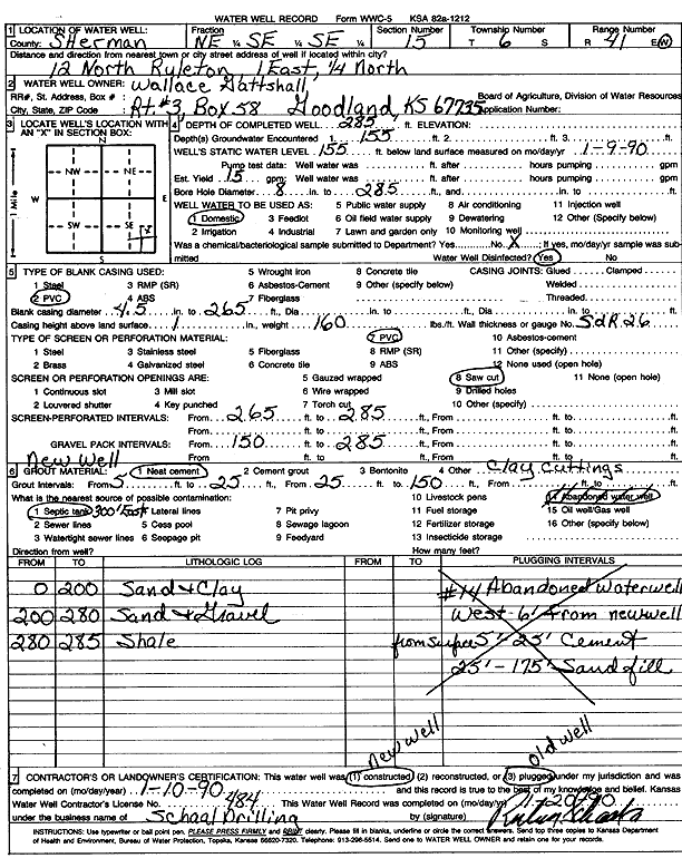
Specific Water Well Detail |
|
|
| Location Info | |||
| Owner: Gattshall, Wallace | Status: Constructed | ||
| Location: T6S, R41W, Sec. 15, NE SE SE | County: Sherman | ||
| Directions: from Ruleton, 12 mi N, 1 mi E, and 0.25 mi N | |||
| Latitude: 39.5275296 | Longitude: -101.8740002 | Datum NAD 27 | |
| Latitude: 39.5275251 | Longitude: -101.8744557 | Datum NAD 83 | |
| Longitude and latitude calculated by Survey from township-range-section-quarter calls. Only good to within the quarter call accuracy. | |||
| View well on interactive map | |||
| General Info | ||
| Well Depth: 285 ft. | Elevation: ft. | |
| Static Water Level: 155 ft. | Est. Yield: 15 gpm. | |
| Comp. Date: 10-Jan-1990 | Well Use: Domestic | |
| DWR Applic. #: | Other ID: | |
| Driller Info | ||
| Driller: Ruben T. Schaal Drilling Co. | License #: 484 | |
| Scanned Form | View scan |
|
Chemical Sample Submitted?: No
Water Well disinfected?: | ||
| Ground water encountered: 155 ft. , 0 ft. , 0 ft. | ||
| Pump test data: Well water was 0 ft after 0 hours pumping 0 gpm | ||
| Casing Info | ||
| Casing Type: PVC
Casing Joints: |
Diam: 4 in. to 265 ft
Diam: 0 in. to 0 ft Diam: 0 in. to 0 ft | |
| Casing height above land surface: in
Casing Weight: lbs/ft Wall thickness or gauge no.: | ||
| Screen and Perforation Info | ||
| Screen Type: PVC | Screen Openings: Saw cut | |
| Screen-perforated intervals | From: 265 ft to 285 ft
From: 0 ft to 0 ft From: 0 ft to 0 ft | |
| Gravel pack intervals | From: ft to ft | |
| Grout Info | ||
| Grout used: Neat cement | From: 5 to 150 ft
From: 0 to 0 ft From: 0 to 0 ft | |
| Source of Possible Contamination | ||
| Source: Septic Tank | ||
| Direction from well: | Distance: 0 ft | |
| Lithologic Log
(Log data entered by KGS.) | ||
| From: 0 ft. to 200 ft. | Sand and clay | |
| From: 200 ft. to 280 ft. | Sand and gravel | |
| From: 280 ft. to 285 ft. | Shale | |