|
|
|
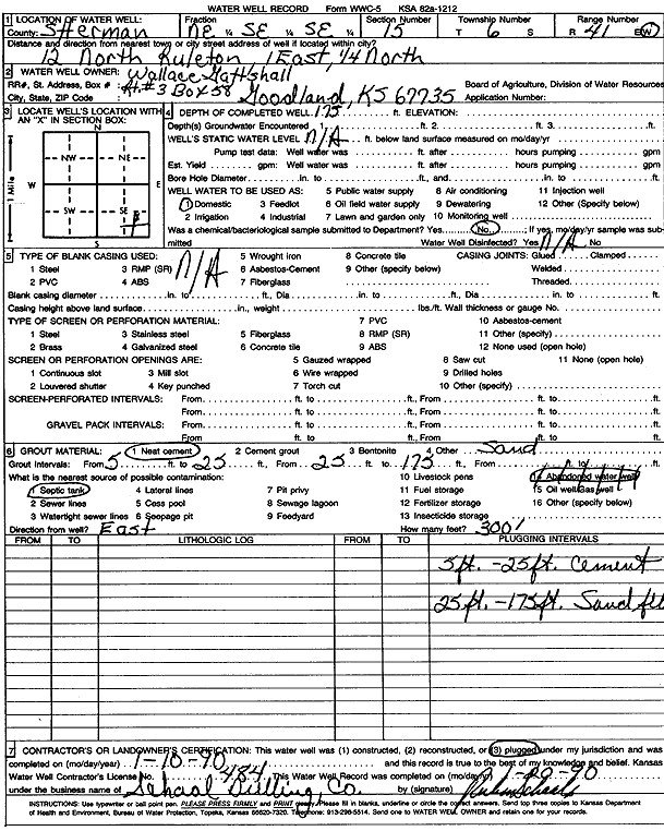
Specific Water Well Detail |
|
|
| Location Info | |||
| Owner: Gattshall, Wallace | Status: Plugged | ||
| Location: T6S, R41W, Sec. 15, NE SE SE | County: Sherman | ||
| Directions: from Ruleton, 12 mi N, 1 mi E, and 0.25 mi N | |||
| Latitude: 39.5275296 | Longitude: -101.8740002 | Datum NAD 27 | |
| Latitude: 39.5275251 | Longitude: -101.8744557 | Datum NAD 83 | |
| Longitude and latitude calculated by Survey from township-range-section-quarter calls. Only good to within the quarter call accuracy. | |||
| View well on interactive map | |||
| General Info | ||
| Well Depth: 175 ft. | Elevation: ft. | |
| Static Water Level: ft. | Est. Yield: gpm. | |
| Comp. Date: 10-Jan-1990 | Well Use: Domestic | |
| DWR Applic. #: | Other ID: | |
| Driller Info | ||
| Driller: Ruben T. Schaal Drilling Co. | License #: 484 | |
| Scanned Form | View scan |
| Casing Info | ||
|
Casing Type:
Diam: 0 in. Casing height above land surface: in | ||
| Grout Info | ||
| Grout used: Neat cement | From: 5 to 175 ft
From: 0 to 0 ft From: 0 to 0 ft | |
| Source of Possible Contamination | ||
| Source: Septic Tank | ||
| Direction from well: | Distance: 0 ft | |