|
|
|
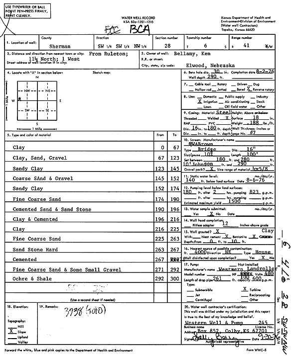
Specific Water Well Detail |
|
|
| Location Info | |||
| Owner: Bellamy, Ken | Status: Constructed | ||
| Location: T6S, R41W, Sec. 28, SW SW NW | County: Sherman | ||
| Directions: from Ruleton, 11.5 mi N and 1 mi W | |||
| Latitude: 39.503795 | Longitude: -101.9092562 | Datum NAD 27 | |
| Latitude: 39.5037906 | Longitude: -101.9097128 | Datum NAD 83 | |
| Longitude and latitude calculated by Survey from township-range-section-quarter calls. Only good to within the quarter call accuracy. | |||
| View well on interactive map | |||
| General Info | ||
| Well Depth: 290 ft. | Elevation: ft. | |
| Static Water Level: 140 ft. | Est. Yield: 1500 gpm. | |
| Comp. Date: 02-Aug-1976 | Well Use: Irrigation | |
| DWR Applic. #: | Other ID: | |
| Links | |
| View info from Wizard Water Level Data base... | |
| View info from WIMAS Water Right Data base... | |
| Driller Info | ||
| Driller: Western Well & Pump, Inc. | License #: 245 | |
| Scanned Form | View scan |
|
Chemical Sample Submitted?: No
Water Well disinfected?: | ||
| Ground water encountered: 0 ft. , 0 ft. , 0 ft. | ||
| Pump test data: Well water was 0 ft after 0 hours pumping 0 gpm | ||
| Casing Info | ||
| Casing Type:
Casing Joints: |
Diam: 0 in. to 0 ft
Diam: 0 in. to 0 ft Diam: 0 in. to 0 ft | |
| Casing height above land surface: in
Casing Weight: lbs/ft Wall thickness or gauge no.: | ||
| Screen and Perforation Info | ||
| Screen Type: | Screen Openings: | |
| Screen-perforated intervals | From: 180 ft to 290 ft
From: 0 ft to 0 ft From: 0 ft to 0 ft | |
| Gravel pack intervals | From: ft to ft | |
| Grout Info | ||
| Grout used: | From: 0 to 0 ft
From: 0 to 0 ft From: 0 to 0 ft | |
| Source of Possible Contamination | ||
| Source: | ||
| Direction from well: | Distance: 0 ft | |
| Lithologic Log
(Log data entered by KGS.) | ||
| From: 0 ft. to 67 ft. | Clay | |
| From: 67 ft. to 123 ft. | Clay, sand, gravel | |
| From: 123 ft. to 145 ft. | Sandy clay | |
| From: 145 ft. to 152 ft. | Coarse sand and gravel | |
| From: 152 ft. to 174 ft. | Sandy clay | |
| From: 174 ft. to 190 ft. | Fine coarse sand | |
| From: 190 ft. to 196 ft. | Cemented sand and sandstone | |
| From: 196 ft. to 216 ft. | Clay and cemented | |
| From: 216 ft. to 225 ft. | Clay | |
| From: 225 ft. to 263 ft. | Fine coarse sand | |
| From: 263 ft. to 267 ft. | Sandstone, hard | |
| From: 267 ft. to 271 ft. | Cemented | |
| From: 271 ft. to 292 ft. | Fine coarse sand and some small gravel | |
| From: 292 ft. to 300 ft. | Ochre and shale | |