|
|
|
Specific Water Well Detail |
|
|
| Location Info | |||
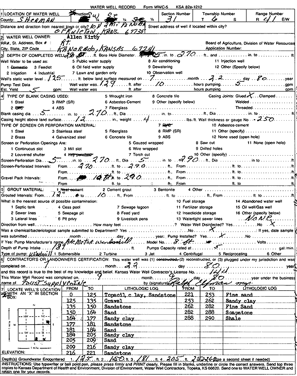
| Owner: Kirby, Allen | Status: Constructed | ||
| Location: T6S, R41W, Sec. 31, SW SE SE | County: Sherman | ||
| Directions: from Ruleton, 10 mi N, 2 mi W, and 0.5 mi N | |||
| Latitude: 39.4819266 | Longitude: -101.9328523 | Datum NAD 27 | |
| Latitude: 39.4819226 | Longitude: -101.9333096 | Datum NAD 83 | |
| Longitude and latitude calculated by Survey from township-range-section-quarter calls. Only good to within the quarter call accuracy. | |||
| View well on interactive map | |||
| General Info | ||
| Well Depth: 290 ft. | Elevation: ft. | |
| Static Water Level: 125 ft. | Est. Yield: 5 gpm. | |
| Comp. Date: 22-Jul-1980 | Well Use: Domestic | |
| DWR Applic. #: | Other ID: | |
| Driller Info | ||
| Driller: A.J. Foust Supply Co. Inc. | License #: 144 | |
| Scanned Form | View scan |
|
Chemical Sample Submitted?: No
Water Well disinfected?: | ||
| Ground water encountered: 0 ft. , 0 ft. , 0 ft. | ||
| Pump test data: Well water was 0 ft after 0 hours pumping 0 gpm | ||
| Casing Info | ||
| Casing Type:
Casing Joints: |
Diam: 0 in. to 0 ft
Diam: 0 in. to 0 ft Diam: 0 in. to 0 ft | |
| Casing height above land surface: in
Casing Weight: lbs/ft Wall thickness or gauge no.: | ||
| Screen and Perforation Info | ||
| Screen Type: | Screen Openings: | |
| Screen-perforated intervals | From: 270 ft to 290 ft
From: 0 ft to 0 ft From: 0 ft to 0 ft | |
| Gravel pack intervals | From: ft to ft | |
| Grout Info | ||
| Grout used: | From: 0 to 0 ft
From: 0 to 0 ft From: 0 to 0 ft | |
| Source of Possible Contamination | ||
| Source: | ||
| Direction from well: | Distance: 0 ft | |
| Lithologic Log
(Log data entered by KGS.) | ||
| From: 0 ft. to 125 ft. | Topsoil, clay, and sandstone | |
| From: 125 ft. to 135 ft. | Gravel | |
| From: 135 ft. to 150 ft. | Sandstone | |
| From: 150 ft. to 164 ft. | Sand | |
| From: 164 ft. to 177 ft. | Sandy clay | |
| From: 177 ft. to 181 ft. | Sandstone | |
| From: 181 ft. to 184 ft. | Sand | |
| From: 184 ft. to 205 ft. | Sandy clay | |
| From: 205 ft. to 209 ft. | Sand | |
| From: 209 ft. to 216 ft. | Sandy clay | |
| From: 216 ft. to 221 ft. | Sandstone | |
| From: 221 ft. to 253 ft. | Fine sand | |
| From: 253 ft. to 262 ft. | Sandy clay | |
| From: 262 ft. to 282 ft. | Fine sand | |
| From: 282 ft. to 288 ft. | Soapstone | |
| From: 288 ft. to 290 ft. | Shale | |