|
|
|
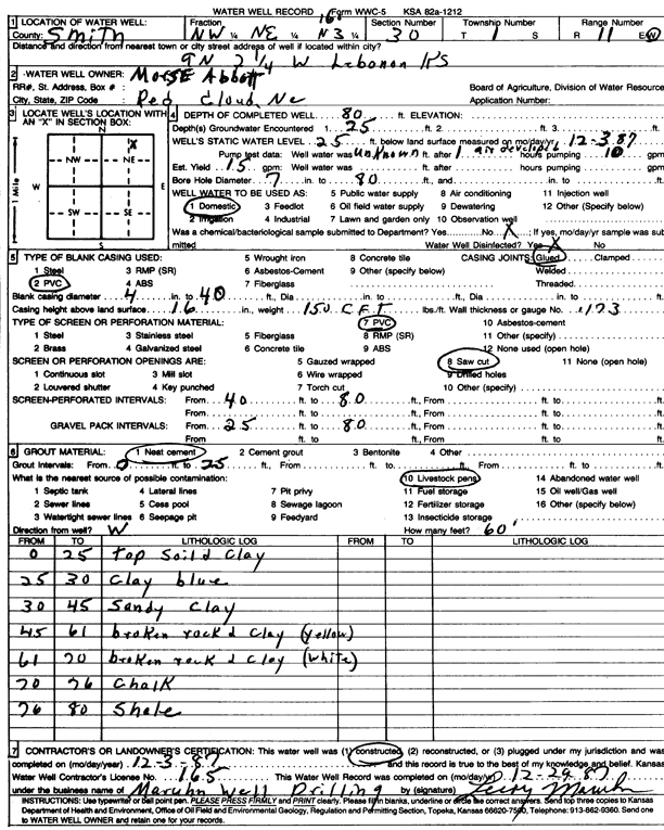
Specific Water Well Detail |
|
|
| Location Info | |||
| Owner: Abbott, Morse | Status: Constructed | ||
| Location: T1S, R11W, Sec. 30, NW NE NE | County: Smith | ||
| Directions: from Lebanon, 9 mi N and 2.25 mi W | |||
| Latitude: 39.943215 | Longitude: -98.6015028 | Datum NAD 27 | |
| Latitude: 39.9432283 | Longitude: -98.6018455 | Datum NAD 83 | |
| Longitude and latitude calculated by Survey from township-range-section-quarter calls. Only good to within the quarter call accuracy. | |||
| View well on interactive map | |||
| General Info | ||
| Well Depth: 80 ft. | Elevation: ft. | |
| Static Water Level: 25 ft. | Est. Yield: 15 gpm. | |
| Comp. Date: 03-Dec-1987 | Well Use: Domestic | |
| DWR Applic. #: | Other ID: | |
| Driller Info | ||
| Driller: Leroy Maruhn Well Drilling, Inc. | License #: 165 | |
| Scanned Form | View scan |
|
Chemical Sample Submitted?: No
Water Well disinfected?: | ||
| Ground water encountered: 25 ft. , 0 ft. , 0 ft. | ||
| Pump test data: Well water was 0 ft after 0 hours pumping 0 gpm | ||
| Casing Info | ||
| Casing Type: PVC
Casing Joints: |
Diam: 4 in. to 40 ft
Diam: 0 in. to 0 ft Diam: 0 in. to 0 ft | |
| Casing height above land surface: in
Casing Weight: lbs/ft Wall thickness or gauge no.: | ||
| Screen and Perforation Info | ||
| Screen Type: Galvanized Steel | Screen Openings: | |
| Screen-perforated intervals | From: 40 ft to 80 ft
From: 0 ft to 0 ft From: 0 ft to 0 ft | |
| Gravel pack intervals | From: ft to ft | |
| Grout Info | ||
| Grout used: Neat cement | From: 0 to 25 ft
From: 0 to 0 ft From: 0 to 0 ft | |
| Source of Possible Contamination | ||
| Source: Livestock pens | ||
| Direction from well: | Distance: 0 ft | |
| Lithologic Log
(Log data entered by KGS.) | ||
| From: 0 ft. to 25 ft. | top soil and clay | |
| From: 25 ft. to 30 ft. | clay, blue | |
| From: 30 ft. to 45 ft. | sandy clay | |
| From: 45 ft. to 61 ft. | broken rock and clay, yellow | |
| From: 61 ft. to 70 ft. | broken rock and clay, white | |
| From: 70 ft. to 76 ft. | chalk | |
| From: 76 ft. to 80 ft. | shale | |