|
|
|
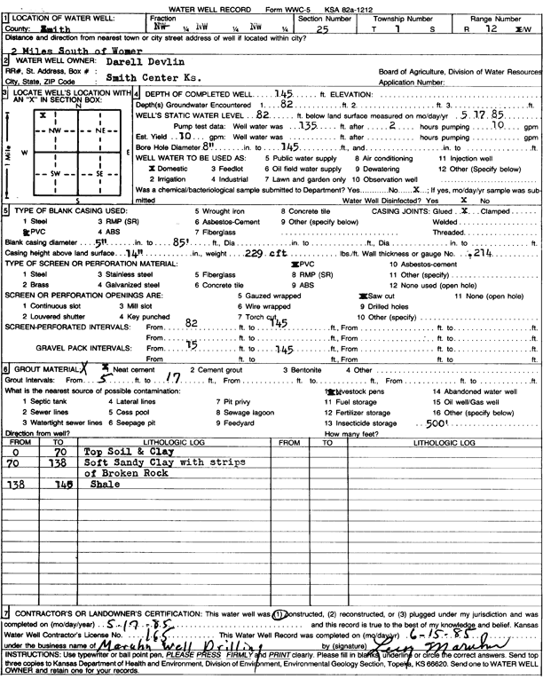
Specific Water Well Detail |
|
|
| Location Info | |||
| Owner: Devlin, Darrell | Status: Constructed | ||
| Location: T1S, R12W, Sec. 25, NW NW NW | County: Smith | ||
| Directions: from Womer, 2 mi S | |||
| Latitude: 39.9433679 | Longitude: -98.6339352 | Datum NAD 27 | |
| Latitude: 39.9433812 | Longitude: -98.6342797 | Datum NAD 83 | |
| Longitude and latitude calculated by Survey from township-range-section-quarter calls. Only good to within the quarter call accuracy. | |||
| View well on interactive map | |||
| General Info | ||
| Well Depth: 145 ft. | Elevation: ft. | |
| Static Water Level: 82 ft. | Est. Yield: 10 gpm. | |
| Comp. Date: 17-May-1985 | Well Use: Domestic | |
| DWR Applic. #: | Other ID: | |
| Driller Info | ||
| Driller: Leroy Maruhn Well Drilling, Inc. | License #: 165 | |
| Scanned Form | View scan |
|
Chemical Sample Submitted?: No
Water Well disinfected?: | ||
| Ground water encountered: 82 ft. , 0 ft. , 0 ft. | ||
| Pump test data: Well water was 135 ft after 2 hours pumping 10 gpm | ||
| Casing Info | ||
| Casing Type: PVC
Casing Joints: |
Diam: 5 in. to 85 ft
Diam: 0 in. to 0 ft Diam: 0 in. to 0 ft | |
| Casing height above land surface: in
Casing Weight: lbs/ft Wall thickness or gauge no.: | ||
| Screen and Perforation Info | ||
| Screen Type: PVC | Screen Openings: Saw cut | |
| Screen-perforated intervals | From: 82 ft to 145 ft
From: 0 ft to 0 ft From: 0 ft to 0 ft | |
| Gravel pack intervals | From: ft to ft | |
| Grout Info | ||
| Grout used: Neat cement | From: 5 to 17 ft
From: 0 to 0 ft From: 0 to 0 ft | |
| Source of Possible Contamination | ||
| Source: Livestock pens | ||
| Direction from well: | Distance: 0 ft | |
| Lithologic Log
(Log data entered by KGS.) | ||
| From: 0 ft. to 70 ft. | top soil and clay | |
| From: 70 ft. to 138 ft. | soft sandy clay with strips of broken rock | |
| From: 138 ft. to 148 ft. | shale | |