|
|
|
Specific Water Well Detail |
|
|
| Location Info | |||
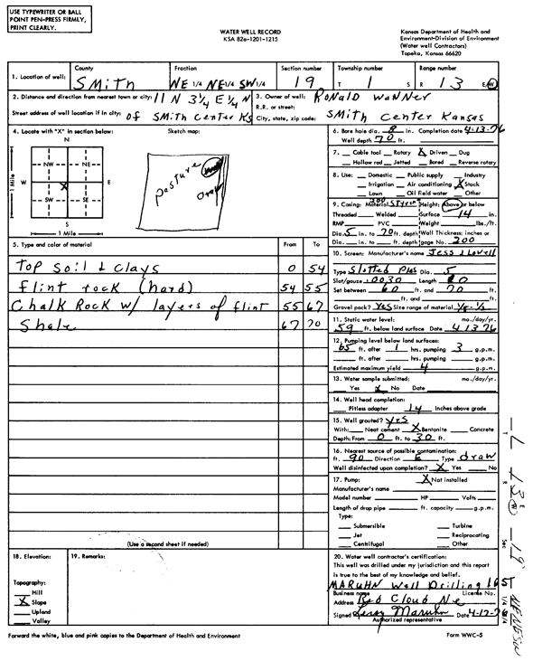
| Owner: Wanner, Ronald | Status: Constructed | ||
| Location: T1S, R13W, Sec. 19, NE NE SW | County: Smith | ||
| Directions: from Smith Center, 11 mi N, 3.25 mi E, and 0.25 mi N | |||
| Latitude: 39.950502 | Longitude: -98.8332333 | Datum NAD 27 | |
| Latitude: 39.9505153 | Longitude: -98.8335871 | Datum NAD 83 | |
| Longitude and latitude calculated by Survey from township-range-section-quarter calls. Only good to within the quarter call accuracy. | |||
| View well on interactive map | |||
| General Info | ||
| Well Depth: 70 ft. | Elevation: ft. | |
| Static Water Level: 59 ft. | Est. Yield: 4 gpm. | |
| Comp. Date: 13-Apr-1976 | Well Use: Domestic, Livestock | |
| DWR Applic. #: | Other ID: | |
| Driller Info | ||
| Driller: Leroy Maruhn Well Drilling, Inc. | License #: 165 | |
| Scanned Form | View scan |
|
Chemical Sample Submitted?: No
Water Well disinfected?: | ||
| Ground water encountered: 0 ft. , 0 ft. , 0 ft. | ||
| Pump test data: Well water was 0 ft after 0 hours pumping 0 gpm | ||
| Casing Info | ||
| Casing Type:
Casing Joints: |
Diam: 0 in. to 0 ft
Diam: 0 in. to 0 ft Diam: 0 in. to 0 ft | |
| Casing height above land surface: in
Casing Weight: lbs/ft Wall thickness or gauge no.: | ||
| Screen and Perforation Info | ||
| Screen Type: | Screen Openings: | |
| Screen-perforated intervals | From: 60 ft to 70 ft
From: 0 ft to 0 ft From: 0 ft to 0 ft | |
| Gravel pack intervals | From: ft to ft | |
| Grout Info | ||
| Grout used: | From: 0 to 0 ft
From: 0 to 0 ft From: 0 to 0 ft | |
| Source of Possible Contamination | ||
| Source: | ||
| Direction from well: | Distance: 0 ft | |
| Lithologic Log
(Log data entered by KGS.) | ||
| From: 0 ft. to 54 ft. | top soil and clays | |
| From: 54 ft. to 55 ft. | flint rock, hard | |
| From: 55 ft. to 67 ft. | chalk rock with layers of flint | |
| From: 67 ft. to 70 ft. | shale | |