|
|
|
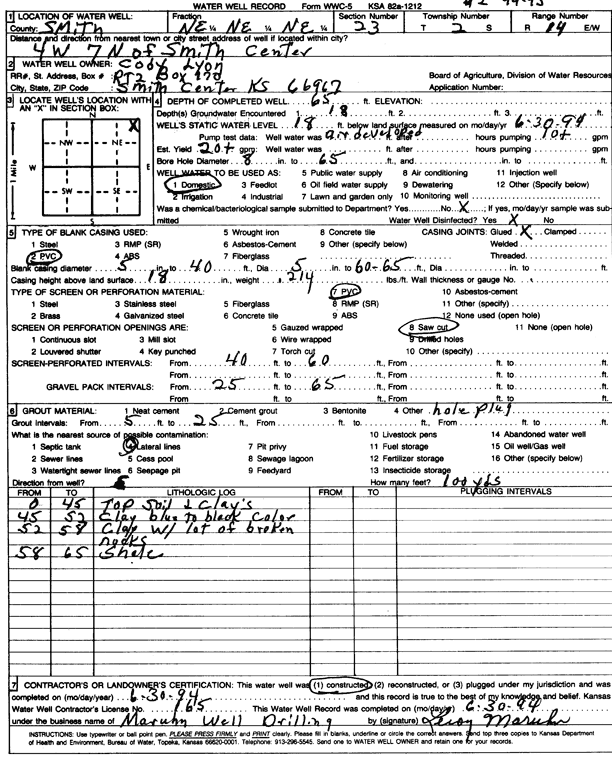
Specific Water Well Detail |
|
|
| Location Info | |||
| Owner: Lyon, Cody | Status: Constructed | ||
| Location: T2S, R14W, Sec. 23, NE NE NE | County: Smith | ||
| Directions: from Smith Center, 4 mi W and 7 mi N | |||
| Latitude: 39.8710527 | Longitude: -98.8616147 | Datum NAD 27 | |
| Latitude: 39.8710653 | Longitude: -98.8619698 | Datum NAD 83 | |
| Longitude and latitude calculated by Survey from township-range-section-quarter calls. Only good to within the quarter call accuracy. | |||
| View well on interactive map | |||
| General Info | ||
| Well Depth: 65 ft. | Elevation: ft. | |
| Static Water Level: 18 ft. | Est. Yield: 20 gpm. | |
| Comp. Date: 30-Jun-1994 | Well Use: Domestic | |
| DWR Applic. #: | Other ID: | |
| Driller Info | ||
| Driller: Maruhn Well Drilling, Inc. | License #: 165 | |
| Scanned Form | View scan |
|
Chemical Sample Submitted?: No
Water Well disinfected?: | ||
| Ground water encountered: 18 ft. , 0 ft. , 0 ft. | ||
| Pump test data: Well water was 0 ft after 0 hours pumping 10 gpm | ||
| Casing Info | ||
| Casing Type: PVC
Casing Joints: |
Diam: 5 in. to 40 ft
Diam: 5 in. to 65 ft Diam: 0 in. to 0 ft | |
| Casing height above land surface: in
Casing Weight: lbs/ft Wall thickness or gauge no.: | ||
| Screen and Perforation Info | ||
| Screen Type: PVC | Screen Openings: Saw cut | |
| Screen-perforated intervals | From: 40 ft to 60 ft
From: 0 ft to 0 ft From: 0 ft to 0 ft | |
| Gravel pack intervals | From: ft to ft | |
| Grout Info | ||
| Grout used: | From: 5 to 25 ft
From: 0 to 0 ft From: 0 to 0 ft | |
| Source of Possible Contamination | ||
| Source: Lateral lines | ||
| Direction from well: | Distance: 0 ft | |
| Lithologic Log
(Log data entered by KGS.) | ||
| From: 0 ft. to 45 ft. | top soil and clays | |
| From: 45 ft. to 52 ft. | clay, blue to black | |
| From: 52 ft. to 58 ft. | clay with lots of broken rocks | |
| From: 58 ft. to 65 ft. | shale | |