|
|
|
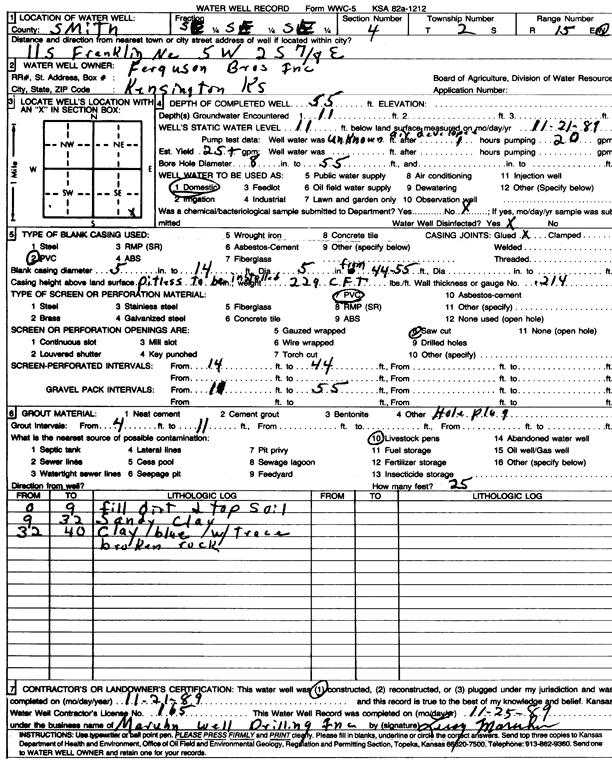
Specific Water Well Detail |
|
|
| Location Info | |||
| Owner: Ferguson Bros. Inc. | Status: Constructed | ||
| Location: T2S, R15W, Sec. 4, SE SE SE | County: Smith | ||
| Directions: from Franklin, NE, 11 mi S, 5 mi W, 2 mi S, and 0.8 mi E | |||
| Latitude: 39.9023039 | Longitude: -99.0116486 | Datum NAD 27 | |
| Latitude: 39.9023163 | Longitude: -99.0120091 | Datum NAD 83 | |
| Longitude and latitude calculated by Survey from township-range-section-quarter calls. Only good to within the quarter call accuracy. | |||
| View well on interactive map | |||
| General Info | ||
| Well Depth: 55 ft. | Elevation: ft. | |
| Static Water Level: 11 ft. | Est. Yield: 25 gpm. | |
| Comp. Date: 21-Nov-1989 | Well Use: Domestic | |
| DWR Applic. #: | Other ID: | |
| Driller Info | ||
| Driller: Leroy Maruhn Well Drilling, Inc. | License #: 165 | |
| Scanned Form | View scan |
|
Chemical Sample Submitted?: No
Water Well disinfected?: | ||
| Ground water encountered: 11 ft. , 0 ft. , 0 ft. | ||
| Pump test data: Well water was 0 ft after 1 hours pumping 20 gpm | ||
| Casing Info | ||
| Casing Type: PVC
Casing Joints: |
Diam: 5 in. to 14 ft
Diam: 5 in. to 55 ft Diam: 0 in. to 0 ft | |
| Casing height above land surface: in
Casing Weight: lbs/ft Wall thickness or gauge no.: | ||
| Screen and Perforation Info | ||
| Screen Type: PVC | Screen Openings: Saw cut | |
| Screen-perforated intervals | From: 14 ft to 44 ft
From: 0 ft to 0 ft From: 0 ft to 0 ft | |
| Gravel pack intervals | From: ft to ft | |
| Grout Info | ||
| Grout used: | From: 4 to 11 ft
From: 0 to 0 ft From: 0 to 0 ft | |
| Source of Possible Contamination | ||
| Source: Livestock pens | ||
| Direction from well: | Distance: 0 ft | |
| Lithologic Log
(Log data entered by KGS.) | ||
| From: 0 ft. to 9 ft. | fill dirt and top soil | |
| From: 9 ft. to 32 ft. | sandy clay | |
| From: 32 ft. to 40 ft. | clay, blue, with traces broken rock | |