|
|
|
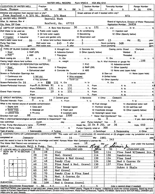
Specific Water Well Detail |
|
|
| Location Info | |||
| Owner: Wark, Darrell | Status: Constructed | ||
| Location: T6S, R31W, Sec. 14, NE SW NW | County: Thomas | ||
| Directions: from Rexford: 4.75 mi N, .75 mi W | |||
| Latitude: 39.5352376 | Longitude: -100.7534913 | Datum NAD 27 | |
| Latitude: 39.5352415 | Longitude: -100.7539177 | Datum NAD 83 | |
| Longitude and latitude calculated by Survey from township-range-section-quarter calls. Only good to within the quarter call accuracy. | |||
| View well on interactive map | |||
| General Info | ||
| Well Depth: 151 ft. | Elevation: ft. | |
| Static Water Level: 86 ft. | Est. Yield: gpm. | |
| Comp. Date: 14-Jan-1981 | Well Use: Irrigation | |
| DWR Applic. #: 34839 | Other ID: | |
| Links | |
| View info from Wizard Water Level Data base... | |
| View info from WIMAS Water Right Data base... | |
| Driller Info | ||
| Driller: Roy Senior, Western Well & Pump, Inc. | License #: 245 | |
| Scanned Form | View scan |
|
Chemical Sample Submitted?: No
Water Well disinfected?: | ||
| Ground water encountered: 0 ft. , 0 ft. , 0 ft. | ||
| Pump test data: Well water was 0 ft after 0 hours pumping 0 gpm | ||
| Casing Info | ||
| Casing Type: Steel
Casing Joints: |
Diam: 16 in. to 91 ft | |
| Casing height above land surface: in
Casing Weight: lbs/ft Wall thickness or gauge no.: | ||
| Screen and Perforation Info | ||
| Screen Type: Steel | Screen Openings: | |
| Screen-perforated intervals | From: 91 ft to 131 ft
From: 131 ft to 151 ft | |
| Gravel pack intervals | From: ft to ft | |
| Grout Info | ||
| Grout used: | From: 0 to 0 ft
From: 0 to 0 ft From: 0 to 0 ft | |
| Source of Possible Contamination | ||
| Source: | ||
| Direction from well: | Distance: 0 ft | |
| Lithologic Log
(Log data entered by KGS.) | ||
| From: 0 ft. to 28 ft. | Clay | |
| From: 28 ft. to 35 ft. | Medium gravel | |
| From: 35 ft. to 42 ft. | Coarse and medium gravel | |
| From: 42 ft. to 48 ft. | Sandy clay | |
| From: 48 ft. to 51 ft. | Fine sand and medium gravel | |
| From: 51 ft. to 60 ft. | Fine sand | |
| From: 60 ft. to 65 ft. | Medium gravel | |
| From: 65 ft. to 70 ft. | Sandy clay and fine sand | |
| From: 70 ft. to 76 ft. | Medium and coarse gravel | |
| From: 76 ft. to 80 ft. | Fine sand | |
| From: 80 ft. to 100 ft. | Medium and coarse gravel | |
| From: 100 ft. to 114 ft. | Fine sand with cement streak | |
| From: 114 ft. to 120 ft. | Sandstone | |
| From: 120 ft. to 124 ft. | Fine sand | |
| From: 124 ft. to 150 ft. | Medium and coarse gravel | |
| From: 150 ft. to 157 ft. | Fine sand | |
| From: 157 ft. to ft. | Ochre and shale | |