|
|
|
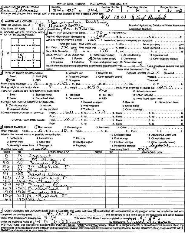
Specific Water Well Detail |
|
|
| Location Info | |||
| Owner: A.L. Abercrombie Drilling | Status: Constructed | ||
| Location: T6S, R31W, Sec. 21, NW NE SW | County: Thomas | ||
| Directions: from Rexford: 4 mi N, 1.5 mi W, .5 mi S | |||
| Latitude: 39.5170259 | Longitude: -100.7886681 | Datum NAD 27 | |
| Latitude: 39.5170296 | Longitude: -100.7890954 | Datum NAD 83 | |
| Longitude and latitude calculated by Survey from township-range-section-quarter calls. Only good to within the quarter call accuracy. | |||
| View well on interactive map | |||
| General Info | ||
| Well Depth: 170 ft. | Elevation: ft. | |
| Static Water Level: 105 ft. | Est. Yield: 50 gpm. | |
| Comp. Date: 10-Apr-1985 | Well Use: Oil Field Water Supply | |
| DWR Applic. #: | Other ID: | |
| Driller Info | ||
| Driller: Joseph Beckman, B & B Drilling | License #: 376 | |
| Scanned Form | View scan |
|
Chemical Sample Submitted?: No
Water Well disinfected?: | ||
| Ground water encountered: 105 ft. , 0 ft. , 0 ft. | ||
| Pump test data: Well water was 0 ft after 0 hours pumping 0 gpm | ||
| Casing Info | ||
| Casing Type: PVC
Casing Joints: |
Diam: 5 in. to 170 ft
Diam: 0 in. to 0 ft Diam: 0 in. to 0 ft | |
| Casing height above land surface: in
Casing Weight: lbs/ft Wall thickness or gauge no.: | ||
| Screen and Perforation Info | ||
| Screen Type: PVC | Screen Openings: Continuous slot | |
| Screen-perforated intervals | From: 160 ft to 170 ft
From: 0 ft to 0 ft From: 0 ft to 0 ft | |
| Gravel pack intervals | From: ft to ft | |
| Grout Info | ||
| Grout used: Neat cement | From: 0 to 10 ft
From: 0 to 0 ft From: 0 to 0 ft | |
| Source of Possible Contamination | ||
| Source: | ||
| Direction from well: | Distance: 0 ft | |
| Lithologic Log
(Log data entered by KGS.) | ||
| From: 0 ft. to 18 ft. | Top soil | |
| From: 18 ft. to 40 ft. | Medium gravel | |
| From: 40 ft. to 56 ft. | Sandy clay | |
| From: 56 ft. to 79 ft. | Medium gravel | |
| From: 79 ft. to 91 ft. | Gravel | |
| From: 91 ft. to 105 ft. | Sandy clay | |
| From: 105 ft. to 112 ft. | Sandstone | |
| From: 112 ft. to 122 ft. | Medium gravel | |
| From: 122 ft. to 143 ft. | Sandy clay | |
| From: 143 ft. to 150 ft. | Medium gravel | |
| From: 150 ft. to 156 ft. | Sandy clay | |
| From: 156 ft. to 168 ft. | Medium gravel | |
| From: 168 ft. to 170 ft. | Ochre | |