|
|
|
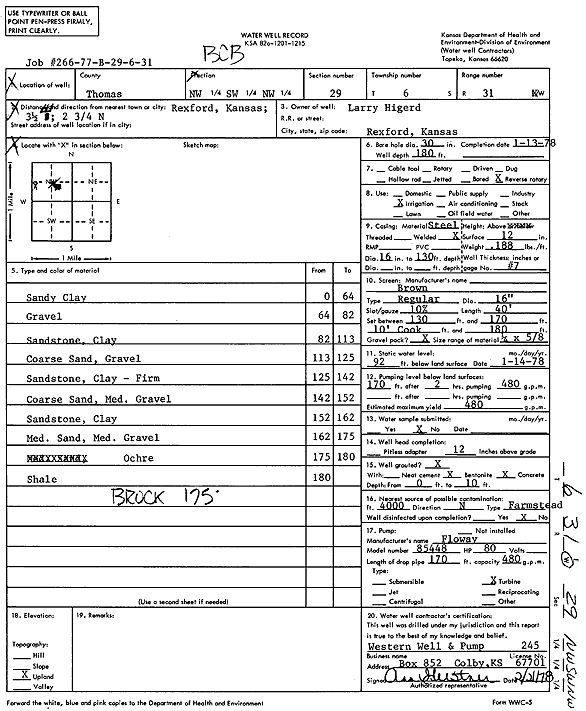
Specific Water Well Detail |
|
|
| Location Info | |||
| Owner: Higerd, Larry | Status: Constructed | ||
| Location: T6S, R31W, Sec. 29, NW SW NW | County: Thomas | ||
| Directions: from Rexford: 3.5 mi W, 2.75 mi N | |||
| Latitude: 39.5060062 | Longitude: -100.8121911 | Datum NAD 27 | |
| Latitude: 39.5060098 | Longitude: -100.812619 | Datum NAD 83 | |
| Longitude and latitude calculated by Survey from township-range-section-quarter calls. Only good to within the quarter call accuracy. | |||
| View well on interactive map | |||
| General Info | ||
| Well Depth: 180 ft. | Elevation: ft. | |
| Static Water Level: 92 ft. | Est. Yield: 480 gpm. | |
| Comp. Date: 13-Jan-1978 | Well Use: Irrigation | |
| DWR Applic. #: | Other ID: | |
| Links | |
| View info from Wizard Water Level Data base... | |
| View info from WIMAS Water Right Data base... | |
| Driller Info | ||
| Driller: Western Well & Pump, Inc. | License #: 245 | |
| Scanned Form | View scan |
|
Chemical Sample Submitted?: No
Water Well disinfected?: | ||
| Ground water encountered: 0 ft. , 0 ft. , 0 ft. | ||
| Pump test data: Well water was 0 ft after 0 hours pumping 0 gpm | ||
| Casing Info | ||
| Casing Type:
Casing Joints: |
Diam: 0 in. to 0 ft
Diam: 0 in. to 0 ft Diam: 0 in. to 0 ft | |
| Casing height above land surface: in
Casing Weight: lbs/ft Wall thickness or gauge no.: | ||
| Screen and Perforation Info | ||
| Screen Type: | Screen Openings: | |
| Screen-perforated intervals | From: 130 ft to 170 ft
From: 170 ft to 180 ft From: 0 ft to 0 ft | |
| Gravel pack intervals | From: ft to ft | |
| Grout Info | ||
| Grout used: | From: 0 to 0 ft
From: 0 to 0 ft From: 0 to 0 ft | |
| Source of Possible Contamination | ||
| Source: | ||
| Direction from well: | Distance: 0 ft | |
| Lithologic Log
(Log data entered by KGS.) | ||
| From: 0 ft. to 64 ft. | Sandy clay | |
| From: 64 ft. to 82 ft. | Gravel | |
| From: 82 ft. to 113 ft. | Sandstone, clay | |
| From: 113 ft. to 125 ft. | Coarse sand, gravel | |
| From: 125 ft. to 142 ft. | Sandstone, clay - firm | |
| From: 142 ft. to 152 ft. | Coarse sand, medium gravel | |
| From: 152 ft. to 162 ft. | Sandstone, clay | |
| From: 162 ft. to 175 ft. | Medium sand, medium gravel | |
| From: 175 ft. to 180 ft. | Ochre | |
| From: 180 ft. to ft. | Shale | |