|
|
|
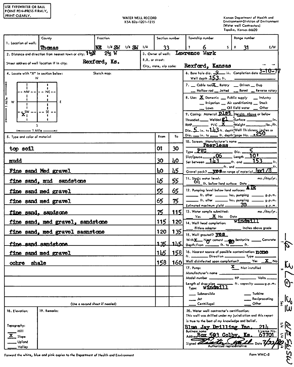
Specific Water Well Detail |
|
|
| Location Info | |||
| Owner: Wark, Lawrence | Status: Constructed | ||
| Location: T6S, R31W, Sec. 33, NE SW SW | County: Thomas | ||
| Directions: from Rexford: 1.5 mi N, 2.5 mi W | |||
| Latitude: 39.4843605 | Longitude: -100.7913273 | Datum NAD 27 | |
| Latitude: 39.4843643 | Longitude: -100.7917544 | Datum NAD 83 | |
| Longitude and latitude calculated by Survey from township-range-section-quarter calls. Only good to within the quarter call accuracy. | |||
| View well on interactive map | |||
| General Info | ||
| Well Depth: 153 ft. | Elevation: ft. | |
| Static Water Level: 64 ft. | Est. Yield: 70 gpm. | |
| Comp. Date: 10-Mar-1977 | Well Use: Domestic | |
| DWR Applic. #: | Other ID: | |
| Driller Info | ||
| Driller: Blue Jay Drilling Co., Inc. | License #: 214 | |
| Scanned Form | View scan |
|
Chemical Sample Submitted?: No
Water Well disinfected?: | ||
| Ground water encountered: 0 ft. , 0 ft. , 0 ft. | ||
| Pump test data: Well water was 0 ft after 0 hours pumping 0 gpm | ||
| Casing Info | ||
| Casing Type:
Casing Joints: |
Diam: 0 in. to 0 ft
Diam: 0 in. to 0 ft Diam: 0 in. to 0 ft | |
| Casing height above land surface: in
Casing Weight: lbs/ft Wall thickness or gauge no.: | ||
| Screen and Perforation Info | ||
| Screen Type: | Screen Openings: | |
| Screen-perforated intervals | From: 143 ft to 153 ft
From: 0 ft to 0 ft From: 0 ft to 0 ft | |
| Gravel pack intervals | From: ft to ft | |
| Grout Info | ||
| Grout used: | From: 0 to 0 ft
From: 0 to 0 ft From: 0 to 0 ft | |
| Source of Possible Contamination | ||
| Source: | ||
| Direction from well: | Distance: 0 ft | |
| Lithologic Log
(Log data entered by KGS.) | ||
| From: 1 ft. to 30 ft. | Topsoil | |
| From: 30 ft. to 40 ft. | Mud | |
| From: 40 ft. to 45 ft. | Fine sand, medium gravel | |
| From: 45 ft. to 55 ft. | Fine sand, mud, sandstone | |
| From: 55 ft. to 65 ft. | Fine sand, medium gravel | |
| From: 65 ft. to 75 ft. | Fine sand, medium gravel | |
| From: 75 ft. to 115 ft. | Fine sand, sandstone | |
| From: 115 ft. to 120 ft. | Fine sand, medium gravel, sandstone | |
| From: 120 ft. to 135 ft. | Fine sand, medium gravel, sandstone | |
| From: 135 ft. to 145 ft. | Fine sand, sandstone | |
| From: 145 ft. to 158 ft. | Fine sand, medium gravel | |
| From: 158 ft. to 160 ft. | Ochre, shale | |