|
|
|
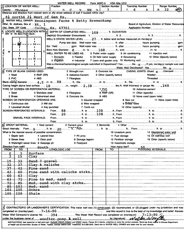
Specific Water Well Detail |
|
|
| Location Info | |||
| Owner: Henningsen Farms | Status: Constructed | ||
| Location: T6S, R32W, Sec. 7, C NW | County: Thomas | ||
| Directions: from Gem: 8.5 mi N, 2.5 mi W | |||
| Latitude: 39.5502164 | Longitude: -100.9375137 | Datum NAD 27 | |
| Latitude: 39.5502194 | Longitude: -100.9379448 | Datum NAD 83 | |
| Longitude and latitude calculated by Survey from township-range-section-quarter calls. Only good to within the quarter call accuracy. | |||
| View well on interactive map | |||
| General Info | ||
| Well Depth: 108 ft. | Elevation: ft. | |
| Static Water Level: 27 ft. | Est. Yield: gpm. | |
| Comp. Date: 16-Jul-1990 | Well Use: Domestic | |
| DWR Applic. #: | Other ID: | |
| Driller Info | ||
| Driller: Wade Ewbank, Inc. | License #: 334 | |
| Scanned Form | View scan |
|
Chemical Sample Submitted?: No
Water Well disinfected?: | ||
| Ground water encountered: 0 ft. , 0 ft. , 0 ft. | ||
| Pump test data: Well water was 0 ft after 0 hours pumping 0 gpm | ||
| Casing Info | ||
| Casing Type: PVC
Casing Joints: |
Diam: 4 in. to 88 ft
Diam: 0 in. to 0 ft Diam: 0 in. to 0 ft | |
| Casing height above land surface: in
Casing Weight: lbs/ft Wall thickness or gauge no.: | ||
| Screen and Perforation Info | ||
| Screen Type: PVC | Screen Openings: Saw cut | |
| Screen-perforated intervals | From: 88 ft to 108 ft
From: 0 ft to 0 ft From: 0 ft to 0 ft | |
| Gravel pack intervals | From: ft to ft | |
| Grout Info | ||
| Grout used: Cement grout | From: 0 to 20 ft
From: 0 to 0 ft From: 0 to 0 ft | |
| Source of Possible Contamination | ||
| Source: Abandoned water well | ||
| Direction from well: | Distance: 0 ft | |
| Lithologic Log
(Log data entered by KGS.) | ||
| From: 0 ft. to 3 ft. | Surface | |
| From: 3 ft. to 15 ft. | Clay | |
| From: 15 ft. to 32 ft. | Sand and gravel | |
| From: 32 ft. to 37 ft. | Clay and caliche | |
| From: 37 ft. to 42 ft. | Fine sand | |
| From: 42 ft. to 60 ft. | Fine sand with caliche streaks | |
| From: 60 ft. to 63 ft. | Clay | |
| From: 63 ft. to 72 ft. | Fine to medium sand | |
| From: 72 ft. to 85 ft. | Medium sand with clay streaks | |
| From: 85 ft. to 103 ft. | Medium sand | |
| From: 103 ft. to 105 ft. | Ochre | |
| From: 105 ft. to 108 ft. | Shale | |