|
|
|
Specific Water Well Detail |
|
|
| Location Info | |||
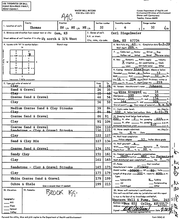
| Owner: Ziegelmeier, Carl | Status: Constructed | ||
| Location: T6S, R32W, Sec. 32, SW NE NE | County: Thomas | ||
| Directions: From Gem, 4.5 miles North and .75 mile West | |||
| Latitude: 39.4932057 | Longitude: -100.9097518 | Datum NAD 27 | |
| Latitude: 39.493209 | Longitude: -100.910182 | Datum NAD 83 | |
| Longitude and latitude calculated by Survey from township-range-section-quarter calls. Only good to within the quarter call accuracy. | |||
| View well on interactive map | |||
| General Info | ||
| Well Depth: 204 ft. | Elevation: ft. | |
| Static Water Level: 102 ft. | Est. Yield: 610 gpm. | |
| Comp. Date: 07-Jun-1979 | Well Use: Irrigation | |
| DWR Applic. #: | Other ID: | |
| Links | |
| No Wizard information available. | |
| View info from WIMAS Water Right Data base... | |
| Driller Info | ||
| Driller: Roy Senior, Western Well & Pump, Inc. | License #: 245 | |
| Scanned Form | View scan |
|
Chemical Sample Submitted?: No
Water Well disinfected?: | ||
| Ground water encountered: 0 ft. , 0 ft. , 0 ft. | ||
| Pump test data: Well water was 0 ft after 0 hours pumping 0 gpm | ||
| Casing Info | ||
| Casing Type:
Casing Joints: |
Diam: 0 in. to 0 ft
Diam: 0 in. to 0 ft Diam: 0 in. to 0 ft | |
| Casing height above land surface: in
Casing Weight: lbs/ft Wall thickness or gauge no.: | ||
| Screen and Perforation Info | ||
| Screen Type: | Screen Openings: | |
| Screen-perforated intervals | From: 144 ft to 154 ft
From: 0 ft to 0 ft From: 0 ft to 0 ft | |
| Gravel pack intervals | From: ft to ft | |
| Grout Info | ||
| Grout used: | From: 0 to 0 ft
From: 0 to 0 ft From: 0 to 0 ft | |
| Source of Possible Contamination | ||
| Source: | ||
| Direction from well: | Distance: 0 ft | |
| Lithologic Log
(Log data entered by KGS.) | ||
| From: 0 ft. to 26 ft. | Clay | |
| From: 26 ft. to 35 ft. | Sand and gravel | |
| From: 35 ft. to 46 ft. | Clay | |
| From: 46 ft. to 56 ft. | Coarse sand and gravel | |
| From: 56 ft. to 59 ft. | Clay | |
| From: 59 ft. to 84 ft. | Medium coarse sand and clay streaks | |
| From: 84 ft. to 86 ft. | Clay | |
| From: 86 ft. to 91 ft. | Coarse sand and gravel | |
| From: 91 ft. to 104 ft. | Clay | |
| From: 104 ft. to 110 ft. | Coarse sand and gravel | |
| From: 110 ft. to 122 ft. | Sandstone - clay and gravel streaks | |
| From: 122 ft. to 127 ft. | Clay | |
| From: 127 ft. to 134 ft. | Sand and clay mix | |
| From: 134 ft. to 151 ft. | Coarse sand and gravel | |
| From: 151 ft. to 161 ft. | Sandy clay | |
| From: 161 ft. to 165 ft. | Clay | |
| From: 165 ft. to 175 ft. | Sandstone - clay and gravel streaks | |
| From: 175 ft. to 179 ft. | Clay | |
| From: 179 ft. to 199 ft. | White, coarse sand and gravel | |
| From: 199 ft. to 215 ft. | Ochre and shale | |