|
|
|
Specific Water Well Detail |
|
|
| Location Info | |||
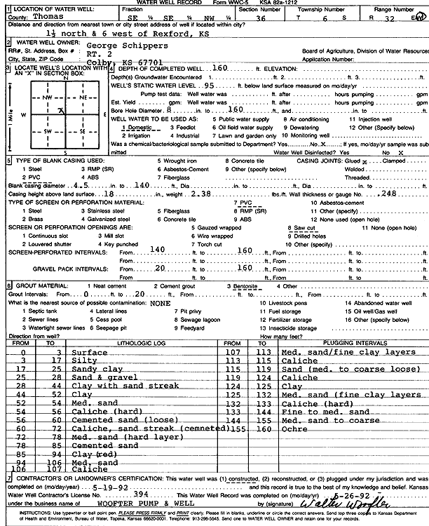
| Owner: Schippers, George | Status: Constructed | ||
| Location: T6S, R32W, Sec. 36, SE SE NW | County: Thomas | ||
| Directions: from Rexford: 1.5 mi N, 6 mi W | |||
| Latitude: 39.4895723 | Longitude: -100.8420954 | Datum NAD 27 | |
| Latitude: 39.4895759 | Longitude: -100.8425239 | Datum NAD 83 | |
| Longitude and latitude calculated by Survey from township-range-section-quarter calls. Only good to within the quarter call accuracy. | |||
| View well on interactive map | |||
| General Info | ||
| Well Depth: 160 ft. | Elevation: ft. | |
| Static Water Level: 95 ft. | Est. Yield: gpm. | |
| Comp. Date: 19-May-1992 | Well Use: Domestic | |
| DWR Applic. #: | Other ID: | |
| Driller Info | ||
| Driller: Walter Woofter Pump & Well | License #: 394 | |
| Scanned Form | View scan |
|
Chemical Sample Submitted?: No
Water Well disinfected?: | ||
| Ground water encountered: 0 ft. , 0 ft. , 0 ft. | ||
| Pump test data: Well water was 0 ft after 0 hours pumping 0 gpm | ||
| Casing Info | ||
| Casing Type: PVC
Casing Joints: |
Diam: 4 in. to 140 ft
Diam: 0 in. to 0 ft Diam: 0 in. to 0 ft | |
| Casing height above land surface: in
Casing Weight: lbs/ft Wall thickness or gauge no.: | ||
| Screen and Perforation Info | ||
| Screen Type: PVC | Screen Openings: Saw cut | |
| Screen-perforated intervals | From: 140 ft to 160 ft
From: 0 ft to 0 ft From: 0 ft to 0 ft | |
| Gravel pack intervals | From: ft to ft | |
| Grout Info | ||
| Grout used: Bentonite | From: 0 to 20 ft
From: 0 to 0 ft From: 0 to 0 ft | |
| Source of Possible Contamination | ||
| Source: OTHER | ||
| Direction from well: | Distance: 0 ft | |
| Lithologic Log
(Log data entered by KGS.) | ||
| From: 0 ft. to 3 ft. | Surface | |
| From: 3 ft. to 17 ft. | Silty | |
| From: 17 ft. to 25 ft. | Sandy clay | |
| From: 25 ft. to 28 ft. | Sand and gravel | |
| From: 28 ft. to 44 ft. | Clay with sand streak | |
| From: 44 ft. to 52 ft. | Clay | |
| From: 52 ft. to 54 ft. | Medium sand | |
| From: 54 ft. to 56 ft. | Caliche, hard | |
| From: 56 ft. to 60 ft. | Cemented sand, loose | |
| From: 60 ft. to 72 ft. | Caliche, sand streak, cemented | |
| From: 72 ft. to 78 ft. | Medium sand, hard layer | |
| From: 78 ft. to 85 ft. | Cemented sand | |
| From: 85 ft. to 94 ft. | Clay, red | |
| From: 94 ft. to 106 ft. | Medium sand | |
| From: 106 ft. to 107 ft. | Caliche | |
| From: 107 ft. to 113 ft. | Medium sand / fine clay layers | |
| From: 113 ft. to 115 ft. | Caliche | |
| From: 115 ft. to 119 ft. | Sand, medium to coarse, loose | |
| From: 119 ft. to 124 ft. | Caliche | |
| From: 124 ft. to 125 ft. | Clay | |
| From: 125 ft. to 132 ft. | Medium sand, fine clay layers | |
| From: 132 ft. to 133 ft. | Caliche, hard | |
| From: 133 ft. to 144 ft. | Fine to medium sand | |
| From: 144 ft. to 155 ft. | Medium sand to coarse | |
| From: 155 ft. to 160 ft. | Ochre | |