|
|
|
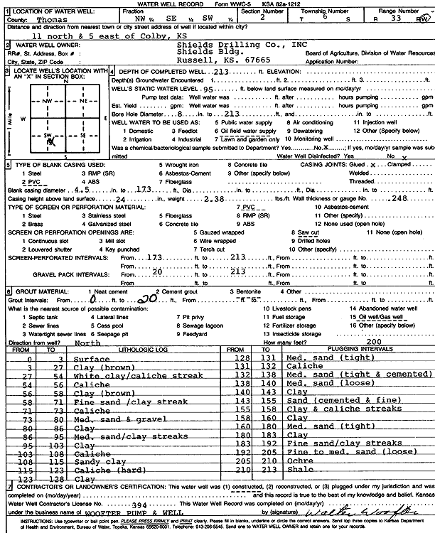
Specific Water Well Detail |
|
|
| Location Info | |||
| Owner: Shields Drilling Co. | Status: Constructed | ||
| Location: T6S, R33W, Sec. 2, NW SE SW | County: Thomas | ||
| Directions: from Colby: 11 mi N, 5 mi E | |||
| Latitude: 39.556498 | Longitude: -100.9734445 | Datum NAD 27 | |
| Latitude: 39.5565007 | Longitude: -100.9738765 | Datum NAD 83 | |
| Longitude and latitude calculated by Survey from township-range-section-quarter calls. Only good to within the quarter call accuracy. | |||
| View well on interactive map | |||
| General Info | ||
| Well Depth: 213 ft. | Elevation: ft. | |
| Static Water Level: 95 ft. | Est. Yield: gpm. | |
| Comp. Date: 01-Jun-1992 | Well Use: Oil Field Water Supply | |
| DWR Applic. #: | Other ID: | |
| Driller Info | ||
| Driller: Walter Woofter Pump & Well | License #: 394 | |
| Scanned Form | View scan |
|
Chemical Sample Submitted?: No
Water Well disinfected?: | ||
| Ground water encountered: 0 ft. , 0 ft. , 0 ft. | ||
| Pump test data: Well water was 0 ft after 0 hours pumping 0 gpm | ||
| Casing Info | ||
| Casing Type: PVC
Casing Joints: |
Diam: 4 in. to 173 ft
Diam: 0 in. to 0 ft Diam: 0 in. to 0 ft | |
| Casing height above land surface: in
Casing Weight: lbs/ft Wall thickness or gauge no.: | ||
| Screen and Perforation Info | ||
| Screen Type: PVC | Screen Openings: Saw cut | |
| Screen-perforated intervals | From: 173 ft to 213 ft
From: 0 ft to 0 ft From: 0 ft to 0 ft | |
| Gravel pack intervals | From: ft to ft | |
| Grout Info | ||
| Grout used: Bentonite | From: 0 to 20 ft
From: 0 to 0 ft From: 0 to 0 ft | |
| Source of Possible Contamination | ||
| Source: Oil well/gas well | ||
| Direction from well: | Distance: 0 ft | |
| Lithologic Log
(Log data entered by KGS.) | ||
| From: 0 ft. to 3 ft. | Surface | |
| From: 3 ft. to 27 ft. | Clay, brown | |
| From: 27 ft. to 54 ft. | White clay / caliche streak | |
| From: 54 ft. to 56 ft. | Caliche | |
| From: 56 ft. to 58 ft. | Clay, brown | |
| From: 58 ft. to 71 ft. | Fine sand / clay streak | |
| From: 71 ft. to 73 ft. | Caliche | |
| From: 73 ft. to 80 ft. | Medium sand and gravel | |
| From: 80 ft. to 86 ft. | Clay | |
| From: 86 ft. to 95 ft. | Medium sand / clay streaks | |
| From: 95 ft. to 103 ft. | Clay | |
| From: 103 ft. to 108 ft. | Caliche | |
| From: 108 ft. to 115 ft. | Sandy clay | |
| From: 115 ft. to 123 ft. | Caliche, hard | |
| From: 123 ft. to 128 ft. | Clay | |
| From: 128 ft. to 131 ft. | Medium sand, tight | |
| From: 131 ft. to 132 ft. | Caliche | |
| From: 132 ft. to 138 ft. | Medium sand, tight and cemented | |
| From: 138 ft. to 140 ft. | Medium sand, loose | |
| From: 140 ft. to 143 ft. | Clay | |
| From: 143 ft. to 155 ft. | Sand, cemented and fine | |
| From: 155 ft. to 158 ft. | Clay and caliche streaks | |
| From: 158 ft. to 160 ft. | Clay | |
| From: 160 ft. to 180 ft. | Medium sand, tight | |
| From: 180 ft. to 192 ft. | Fine sand / clay streaks | |
| From: 192 ft. to 205 ft. | Fine to medium sand, loose | |
| From: 205 ft. to 210 ft. | Ochre | |
| From: 210 ft. to 213 ft. | Shale | |