|
|
|
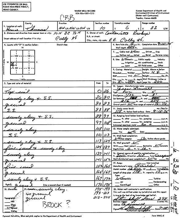
Specific Water Well Detail |
|
|
| Location Info | |||
| Owner: Prokop, Lentoniette | Status: Constructed | ||
| Location: T6S, R33W, Sec. 10, NW NW SW | County: Thomas | ||
| Directions: from Colby: 10 mi N, 3 mi E, .5 mi N | |||
| Latitude: 39.5457473 | Longitude: -100.9969303 | Datum NAD 27 | |
| Latitude: 39.54575 | Longitude: -100.9973628 | Datum NAD 83 | |
| Longitude and latitude calculated by Survey from township-range-section-quarter calls. Only good to within the quarter call accuracy. | |||
| View well on interactive map | |||
| General Info | ||
| Well Depth: 224 ft. | Elevation: ft. | |
| Static Water Level: 118 ft. | Est. Yield: 30 gpm. | |
| Comp. Date: 15-Sep-1975 | Well Use: Domestic | |
| DWR Applic. #: | Other ID: | |
| Driller Info | ||
| Driller: K. Struckhoff, Struckhoff Sons | License #: 298 | |
| Scanned Form | View scan |
|
Chemical Sample Submitted?: No
Water Well disinfected?: | ||
| Ground water encountered: 0 ft. , 0 ft. , 0 ft. | ||
| Pump test data: Well water was 0 ft after 0 hours pumping 0 gpm | ||
| Casing Info | ||
| Casing Type:
Casing Joints: |
Diam: 0 in. to 0 ft
Diam: 0 in. to 0 ft Diam: 0 in. to 0 ft | |
| Casing height above land surface: in
Casing Weight: lbs/ft Wall thickness or gauge no.: | ||
| Screen and Perforation Info | ||
| Screen Type: | Screen Openings: | |
| Screen-perforated intervals | From: 216 ft to 224 ft
From: 0 ft to 0 ft From: 0 ft to 0 ft | |
| Gravel pack intervals | From: ft to ft | |
| Grout Info | ||
| Grout used: | From: 0 to 0 ft
From: 0 to 0 ft From: 0 to 0 ft | |
| Source of Possible Contamination | ||
| Source: | ||
| Direction from well: | Distance: 0 ft | |
| Lithologic Log
(Log data entered by KGS.) | ||
| From: 0 ft. to 36 ft. | Topsoil | |
| From: 36 ft. to 80 ft. | Sandy clay and sandstone | |
| From: 80 ft. to 83 ft. | Gravel | |
| From: 83 ft. to 88 ft. | Sandstone | |
| From: 88 ft. to 97 ft. | Sandy clay and sandstone | |
| From: 97 ft. to 108 ft. | Gravel | |
| From: 108 ft. to 110 ft. | Sandy clay | |
| From: 110 ft. to 113 ft. | Sandstone | |
| From: 113 ft. to 124 ft. | Sandy clay and sandstone | |
| From: 124 ft. to 137 ft. | Fine sand and sandy clay | |
| From: 137 ft. to 141 ft. | Sandy clay | |
| From: 141 ft. to 152 ft. | Gravel | |
| From: 152 ft. to 165 ft. | Fine sand | |
| From: 165 ft. to 167 ft. | Gravel | |
| From: 167 ft. to 172 ft. | Sandy clay and sandstone | |
| From: 172 ft. to 175 ft. | Medium gravel | |
| From: 175 ft. to 193 ft. | Sandy clay | |
| From: 193 ft. to 213 ft. | Medium gravel | |
| From: 213 ft. to 224 ft. | Gravel | |