|
|
|
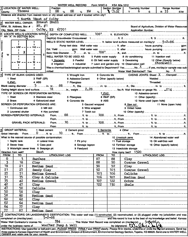
Specific Water Well Detail |
|
|
| Location Info | |||
| Owner: Shull, Ernest | Status: Constructed | ||
| Location: T6S, R33W, Sec. 32, SE SE NW | County: Thomas | ||
| Directions: from Colby: 5 mi N, 1 mi E | |||
| Latitude: 39.4894715 | Longitude: -101.0275267 | Datum NAD 27 | |
| Latitude: 39.4894742 | Longitude: -101.0279597 | Datum NAD 83 | |
| Longitude and latitude calculated by Survey from township-range-section-quarter calls. Only good to within the quarter call accuracy. | |||
| View well on interactive map | |||
| General Info | ||
| Well Depth: 108 ft. | Elevation: ft. | |
| Static Water Level: ft. | Est. Yield: gpm. | |
| Comp. Date: 02-May-1986 | Well Use: Domestic | |
| DWR Applic. #: | Other ID: | |
| Driller Info | ||
| Driller: Walter Woofter Pump & Well | License #: 394 | |
| Scanned Form | View scan |
|
Chemical Sample Submitted?: No
Water Well disinfected?: | ||
| Ground water encountered: 0 ft. , 0 ft. , 0 ft. | ||
| Pump test data: Well water was 0 ft after 0 hours pumping 0 gpm | ||
| Casing Info | ||
| Casing Type: PVC
Casing Joints: |
Diam: 5 in. to 88 ft
Diam: 0 in. to 0 ft Diam: 0 in. to 0 ft | |
| Casing height above land surface: in
Casing Weight: lbs/ft Wall thickness or gauge no.: | ||
| Screen and Perforation Info | ||
| Screen Type: PVC | Screen Openings: Saw cut | |
| Screen-perforated intervals | From: 88 ft to 108 ft
From: 0 ft to 0 ft From: 0 ft to 0 ft | |
| Gravel pack intervals | From: ft to ft | |
| Grout Info | ||
| Grout used: Bentonite | From: 0 to 10 ft
From: 0 to 0 ft From: 0 to 0 ft | |
| Source of Possible Contamination | ||
| Source: Livestock pens | ||
| Direction from well: | Distance: 0 ft | |
| Lithologic Log
(Log data entered by KGS.) | ||
| From: 0 ft. to 3 ft. | Surface | |
| From: 3 ft. to 18 ft. | Clay | |
| From: 18 ft. to 21 ft. | Medium sand | |
| From: 21 ft. to 27 ft. | Sandy clay | |
| From: 27 ft. to 31 ft. | Medium gravel | |
| From: 31 ft. to 35 ft. | Clay and caliche | |
| From: 35 ft. to 42 ft. | Medium gravel | |
| From: 42 ft. to 47 ft. | Clay | |
| From: 47 ft. to 50 ft. | Caliche | |
| From: 50 ft. to 58 ft. | Clay | |
| From: 58 ft. to 60 ft. | Medium sand | |
| From: 60 ft. to 62 ft. | Clay | |
| From: 62 ft. to 64 ft. | Medium sand | |
| From: 64 ft. to 77 ft. | Clay | |
| From: 77 ft. to 87 ft. | Medium sand | |
| From: 87 ft. to 88 ft. | Clay | |
| From: 88 ft. to 90 ft. | Coarse Gravel | |
| From: 90 ft. to 92 ft. | Clay | |
| From: 92 ft. to 103 ft. | Coarse gravel | |
| From: 103 ft. to 106 ft. | Caliche | |
| From: 106 ft. to 107 ft. | Medium sand | |
| From: 107 ft. to 122 ft. | Ochre | |
| From: 122 ft. to 130 ft. | Shale | |