|
|
|
Specific Water Well Detail |
|
|
| Location Info | |||
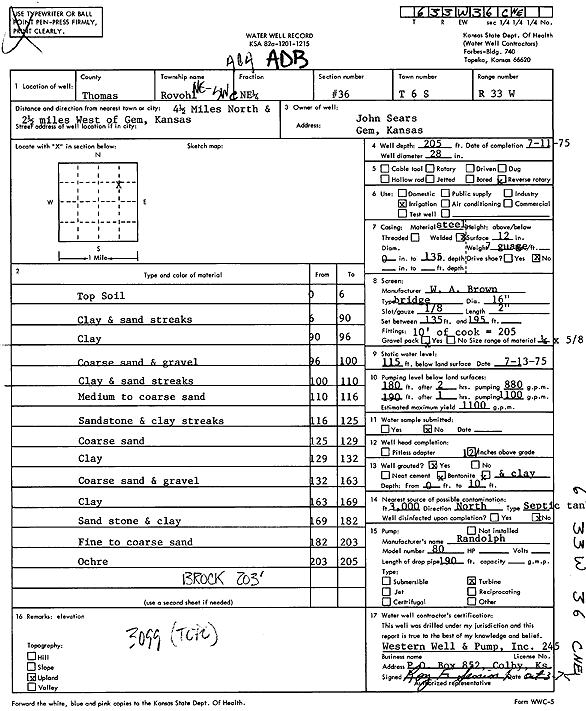
| Owner: Sears, John | Status: Constructed | ||
| Location: T6S, R33W, Sec. 36, C NE | County: Thomas | ||
| Directions: from Gem: 4.5 mi N, 2.5 mi W | |||
| Latitude: 39.4923118 | Longitude: -100.9467227 | Datum NAD 27 | |
| Latitude: 39.4923149 | Longitude: -100.9471538 | Datum NAD 83 | |
| Longitude and latitude calculated by Survey from township-range-section-quarter calls. Only good to within the quarter call accuracy. | |||
| View well on interactive map | |||
| General Info | ||
| Well Depth: 205 ft. | Elevation: ft. | |
| Static Water Level: 115 ft. | Est. Yield: 1100 gpm. | |
| Comp. Date: 11-Jul-1975 | Well Use: Irrigation | |
| DWR Applic. #: | Other ID: | |
| Links | |
| View info from Wizard Water Level Data base... | |
| View info from WIMAS Water Right Data base... | |
| Driller Info | ||
| Driller: Roy Senior, Western Well & Pump, Inc. | License #: 245 | |
| Scanned Form | View scan |
|
Chemical Sample Submitted?: No
Water Well disinfected?: | ||
| Ground water encountered: 0 ft. , 0 ft. , 0 ft. | ||
| Pump test data: Well water was 0 ft after 0 hours pumping 0 gpm | ||
| Casing Info | ||
| Casing Type:
Casing Joints: |
Diam: 0 in. to 0 ft
Diam: 0 in. to 0 ft Diam: 0 in. to 0 ft | |
| Casing height above land surface: in
Casing Weight: lbs/ft Wall thickness or gauge no.: | ||
| Screen and Perforation Info | ||
| Screen Type: | Screen Openings: | |
| Screen-perforated intervals | From: 135 ft to 195 ft
From: 0 ft to 0 ft From: 0 ft to 0 ft | |
| Gravel pack intervals | From: ft to ft | |
| Grout Info | ||
| Grout used: | From: 0 to 0 ft
From: 0 to 0 ft From: 0 to 0 ft | |
| Source of Possible Contamination | ||
| Source: | ||
| Direction from well: | Distance: 0 ft | |
| Lithologic Log
(Log data entered by KGS.) | ||
| From: 0 ft. to 6 ft. | Topsoil | |
| From: 6 ft. to 90 ft. | Clay and sand streaks | |
| From: 90 ft. to 96 ft. | Clay | |
| From: 96 ft. to 100 ft. | Coarse sand and gravel | |
| From: 100 ft. to 110 ft. | Clay and sand streaks | |
| From: 110 ft. to 116 ft. | Medium to coarse sand | |
| From: 116 ft. to 125 ft. | Sandstone and clay streaks | |
| From: 125 ft. to 129 ft. | Coarse sand | |
| From: 129 ft. to 132 ft. | Clay | |
| From: 132 ft. to 163 ft. | Coarse sand and gravel | |
| From: 163 ft. to 169 ft. | Clay | |
| From: 169 ft. to 182 ft. | Sandstone and clay | |
| From: 182 ft. to 203 ft. | Fine to coarse sand | |
| From: 203 ft. to 205 ft. | Ochre | |