|
|
|
Specific Water Well Detail |
|
|
| Location Info | |||
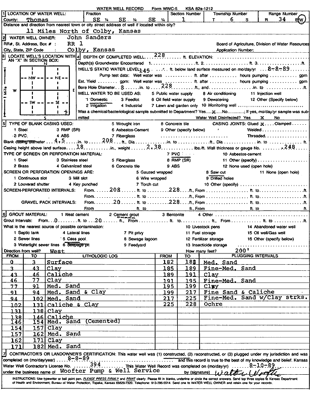
| Owner: Sanders, John | Status: Constructed | ||
| Location: T6S, R34W, Sec. 1, SE SE SE | County: Thomas | ||
| Directions: from Colby: 11 mi N | |||
| Latitude: 39.5547549 | Longitude: -101.0546404 | Datum NAD 27 | |
| Latitude: 39.554757 | Longitude: -101.0550743 | Datum NAD 83 | |
| Longitude and latitude calculated by Survey from township-range-section-quarter calls. Only good to within the quarter call accuracy. | |||
| View well on interactive map | |||
| General Info | ||
| Well Depth: 228 ft. | Elevation: ft. | |
| Static Water Level: 145 ft. | Est. Yield: gpm. | |
| Comp. Date: 08-Aug-1989 | Well Use: Domestic | |
| DWR Applic. #: | Other ID: | |
| Driller Info | ||
| Driller: Walter Woofter Pump & Well | License #: 394 | |
| Scanned Form | View scan |
|
Chemical Sample Submitted?: Yes
Water Well disinfected?: | ||
| Ground water encountered: 0 ft. , 0 ft. , 0 ft. | ||
| Pump test data: Well water was 0 ft after 0 hours pumping 0 gpm | ||
| Casing Info | ||
| Casing Type: PVC
Casing Joints: |
Diam: 4 in. to 208 ft
Diam: 0 in. to 0 ft Diam: 0 in. to 0 ft | |
| Casing height above land surface: in
Casing Weight: lbs/ft Wall thickness or gauge no.: | ||
| Screen and Perforation Info | ||
| Screen Type: PVC | Screen Openings: Saw cut | |
| Screen-perforated intervals | From: 208 ft to 228 ft
From: 0 ft to 0 ft From: 0 ft to 0 ft | |
| Gravel pack intervals | From: ft to ft | |
| Grout Info | ||
| Grout used: Cement grout | From: 0 to 20 ft
From: 0 to 0 ft From: 0 to 0 ft | |
| Source of Possible Contamination | ||
| Source: Cess pool | ||
| Direction from well: | Distance: 0 ft | |
| Lithologic Log
(Log data entered by KGS.) | ||
| From: 0 ft. to 3 ft. | Surface | |
| From: 3 ft. to 43 ft. | Clay | |
| From: 43 ft. to 46 ft. | Caliche | |
| From: 46 ft. to 77 ft. | Clay | |
| From: 77 ft. to 91 ft. | Medium sand | |
| From: 91 ft. to 94 ft. | Medium sand and clay | |
| From: 94 ft. to 102 ft. | Medium sand | |
| From: 102 ft. to 131 ft. | Caliche and clay | |
| From: 131 ft. to 138 ft. | Clay | |
| From: 138 ft. to 146 ft. | Caliche | |
| From: 146 ft. to 154 ft. | Medium sand (cemented) | |
| From: 154 ft. to 157 ft. | Clay | |
| From: 157 ft. to 162 ft. | Medium sand | |
| From: 162 ft. to 171 ft. | Clay | |
| From: 171 ft. to 182 ft. | Medium sand | |
| From: 182 ft. to 185 ft. | Medium sand | |
| From: 185 ft. to 189 ft. | Fine to medium sand | |
| From: 189 ft. to 191 ft. | Clay | |
| From: 191 ft. to 195 ft. | Fine to medium sand | |
| From: 195 ft. to 199 ft. | Clay | |
| From: 199 ft. to 217 ft. | Fine sand and caliche | |
| From: 217 ft. to 225 ft. | Fine to medium sand with clay streaks | |
| From: 225 ft. to 228 ft. | Ochre | |