|
|
|
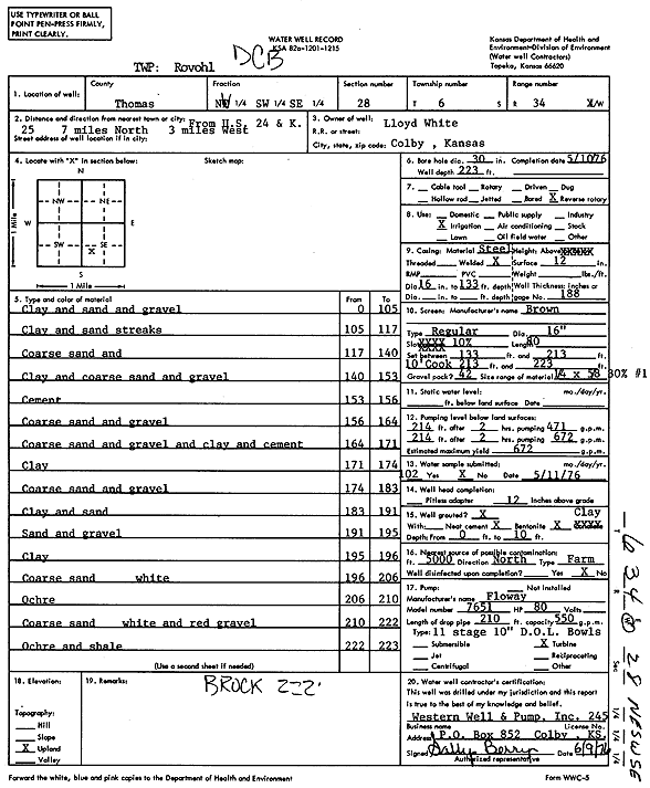
Specific Water Well Detail |
|
|
| Location Info | |||
| Owner: White, Lloyd | Status: Constructed | ||
| Location: T6S, R34W, Sec. 28, NW SW SE | County: Thomas | ||
| Directions: from U.S. 24 and K-25: 7 mi N, 3 mi W | |||
| Latitude: 39.4990547 | Longitude: -101.1182511 | Datum NAD 27 | |
| Latitude: 39.4990567 | Longitude: -101.1186863 | Datum NAD 83 | |
| Longitude and latitude calculated by Survey from township-range-section-quarter calls. Only good to within the quarter call accuracy. | |||
| View well on interactive map | |||
| General Info | ||
| Well Depth: 223 ft. | Elevation: ft. | |
| Static Water Level: ft. | Est. Yield: 672 gpm. | |
| Comp. Date: 10-May-1976 | Well Use: Irrigation | |
| DWR Applic. #: | Other ID: | |
| Links | |
| View info from Wizard Water Level Data base... | |
| View info from WIMAS Water Right Data base... | |
| Driller Info | ||
| Driller: Western Well & Pump, Inc. | License #: 245 | |
| Scanned Form | View scan |
|
Chemical Sample Submitted?: No
Water Well disinfected?: | ||
| Ground water encountered: 0 ft. , 0 ft. , 0 ft. | ||
| Pump test data: Well water was 0 ft after 0 hours pumping 0 gpm | ||
| Casing Info | ||
| Casing Type:
Casing Joints: |
Diam: 0 in. to 0 ft
Diam: 0 in. to 0 ft Diam: 0 in. to 0 ft | |
| Casing height above land surface: in
Casing Weight: lbs/ft Wall thickness or gauge no.: | ||
| Screen and Perforation Info | ||
| Screen Type: | Screen Openings: | |
| Screen-perforated intervals | From: 133 ft to 213 ft
From: 213 ft to 223 ft From: 0 ft to 0 ft | |
| Gravel pack intervals | From: ft to ft | |
| Grout Info | ||
| Grout used: | From: 0 to 0 ft
From: 0 to 0 ft From: 0 to 0 ft | |
| Source of Possible Contamination | ||
| Source: | ||
| Direction from well: | Distance: 0 ft | |
| Lithologic Log
(Log data entered by KGS.) | ||
| From: 0 ft. to 105 ft. | clay and sand and gravel | |
| From: 105 ft. to 117 ft. | clay and sand streaks | |
| From: 117 ft. to 140 ft. | coarse sand and gravel | |
| From: 140 ft. to 153 ft. | clay and coarse sand and gravel | |
| From: 153 ft. to 156 ft. | cement | |
| From: 156 ft. to 164 ft. | coarse sand and gravel | |
| From: 164 ft. to 171 ft. | coarse sand and gravel and clay and cement | |
| From: 171 ft. to 174 ft. | clay | |
| From: 174 ft. to 183 ft. | coarse sand and gravel | |
| From: 183 ft. to 191 ft. | clay and sand | |
| From: 191 ft. to 195 ft. | sand and gravel | |
| From: 195 ft. to 196 ft. | clay | |
| From: 196 ft. to 206 ft. | coarse sand, white | |
| From: 206 ft. to 210 ft. | ochre | |
| From: 210 ft. to 222 ft. | coarse sand, white, and red gravel | |
| From: 222 ft. to 223 ft. | ochre and shale | |