|
|
|
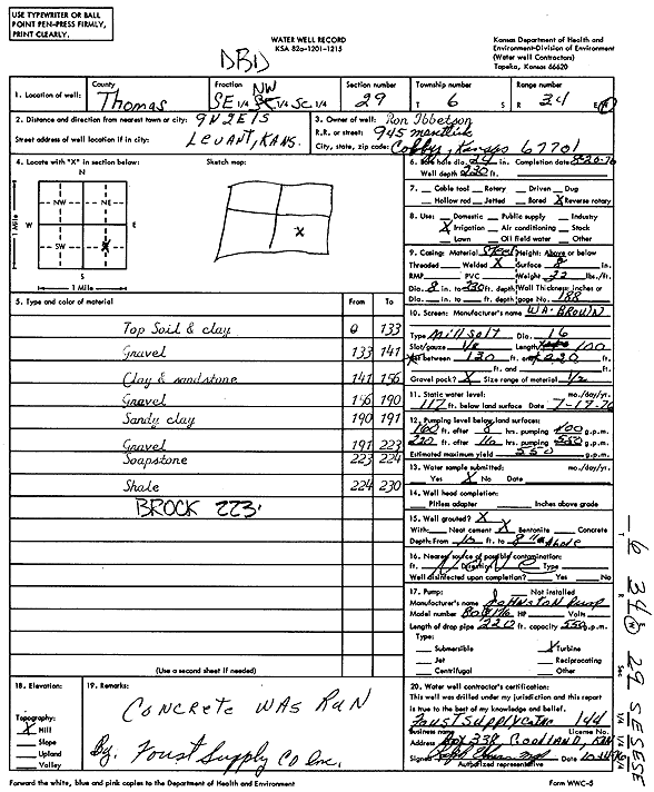
Specific Water Well Detail |
|
|
| Location Info | |||
| Owner: Ibbetson, Ron | Status: Constructed | ||
| Location: T6S, R34W, Sec. 29, SE NW SE | County: Thomas | ||
| Directions: from Levant: 9 mi N, 2 mi E, 1 mi S | |||
| Latitude: 39.5010523 | Longitude: -101.134643 | Datum NAD 27 | |
| Latitude: 39.5010542 | Longitude: -101.1350785 | Datum NAD 83 | |
| Longitude and latitude calculated by Survey from township-range-section-quarter calls. Only good to within the quarter call accuracy. | |||
| View well on interactive map | |||
| General Info | ||
| Well Depth: 230 ft. | Elevation: ft. | |
| Static Water Level: 117 ft. | Est. Yield: 550 gpm. | |
| Comp. Date: 20-Aug-1976 | Well Use: Irrigation | |
| DWR Applic. #: | Other ID: | |
| Links | |
| View info from Wizard Water Level Data base... | |
| View info from WIMAS Water Right Data base... | |
| Driller Info | ||
| Driller: A.J. Foust Supply Co. Inc. | License #: 144 | |
| Scanned Form | View scan |
|
Chemical Sample Submitted?: No
Water Well disinfected?: | ||
| Ground water encountered: 0 ft. , 0 ft. , 0 ft. | ||
| Pump test data: Well water was 0 ft after 0 hours pumping 0 gpm | ||
| Casing Info | ||
| Casing Type:
Casing Joints: |
Diam: 0 in. to 0 ft
Diam: 0 in. to 0 ft Diam: 0 in. to 0 ft | |
| Casing height above land surface: in
Casing Weight: lbs/ft Wall thickness or gauge no.: | ||
| Screen and Perforation Info | ||
| Screen Type: | Screen Openings: | |
| Screen-perforated intervals | From: 130 ft to 230 ft
From: 0 ft to 0 ft From: 0 ft to 0 ft | |
| Gravel pack intervals | From: ft to ft | |
| Grout Info | ||
| Grout used: | From: 0 to 0 ft
From: 0 to 0 ft From: 0 to 0 ft | |
| Source of Possible Contamination | ||
| Source: | ||
| Direction from well: | Distance: 0 ft | |
| Lithologic Log
(Log data entered by KGS.) | ||
| From: 0 ft. to 133 ft. | top soil and clay | |
| From: 133 ft. to 141 ft. | gravel | |
| From: 141 ft. to 156 ft. | clay and sandstone | |
| From: 156 ft. to 190 ft. | gravel | |
| From: 190 ft. to 191 ft. | sandy clay | |
| From: 191 ft. to 223 ft. | gravel | |
| From: 223 ft. to 224 ft. | soapstone | |
| From: 224 ft. to 230 ft. | shale | |