|
|
|
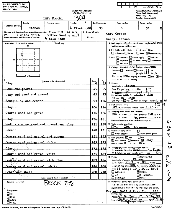
Specific Water Well Detail |
|
|
| Location Info | |||
| Owner: Cooper, Gary | Status: Constructed | ||
| Location: T6S, R34W, Sec. 33, C NW | County: Thomas | ||
| Directions: from U.S. 24 and K-25: 7 mi N, 3 mi W, 0.25 mi S, and 0.25 mi W | |||
| Latitude: 39.4928198 | Longitude: -101.1242083 | Datum NAD 27 | |
| Latitude: 39.4928218 | Longitude: -101.1246435 | Datum NAD 83 | |
| Longitude and latitude calculated by Survey from township-range-section-quarter calls. Only good to within the quarter call accuracy. | |||
| View well on interactive map | |||
| General Info | ||
| Well Depth: 210 ft. | Elevation: ft. | |
| Static Water Level: 89 ft. | Est. Yield: 750 gpm. | |
| Comp. Date: 14-May-1976 | Well Use: Irrigation | |
| DWR Applic. #: | Other ID: | |
| Links | |
| No Wizard information available. | |
| View info from WIMAS Water Right Data base... | |
| Driller Info | ||
| Driller: Western Well & Pump, Inc. | License #: 245 | |
| Scanned Form | View scan |
|
Chemical Sample Submitted?: No
Water Well disinfected?: | ||
| Ground water encountered: 0 ft. , 0 ft. , 0 ft. | ||
| Pump test data: Well water was 0 ft after 0 hours pumping 0 gpm | ||
| Casing Info | ||
| Casing Type:
Casing Joints: |
Diam: 0 in. to 0 ft
Diam: 0 in. to 0 ft Diam: 0 in. to 0 ft | |
| Casing height above land surface: in
Casing Weight: lbs/ft Wall thickness or gauge no.: | ||
| Screen and Perforation Info | ||
| Screen Type: | Screen Openings: | |
| Screen-perforated intervals | From: 120 ft to 210 ft
From: 0 ft to 0 ft From: 0 ft to 0 ft | |
| Gravel pack intervals | From: ft to ft | |
| Grout Info | ||
| Grout used: | From: 0 to 0 ft
From: 0 to 0 ft From: 0 to 0 ft | |
| Source of Possible Contamination | ||
| Source: | ||
| Direction from well: | Distance: 0 ft | |
| Lithologic Log
(Log data entered by KGS.) | ||
| From: 0 ft. to 45 ft. | clay | |
| From: 45 ft. to 55 ft. | sand and gravel | |
| From: 55 ft. to 93 ft. | clay and sand and gravel | |
| From: 93 ft. to 106 ft. | sandy clay and cement | |
| From: 106 ft. to 116 ft. | clay | |
| From: 116 ft. to 126 ft. | coarse sand and gravel | |
| From: 126 ft. to 131 ft. | clay | |
| From: 131 ft. to 148 ft. | medium coarse sand and gravel and clay | |
| From: 148 ft. to 151 ft. | cement | |
| From: 151 ft. to 165 ft. | coarse sand and gravel and cement | |
| From: 165 ft. to 173 ft. | coarse sand and gravel white | |
| From: 173 ft. to 175 ft. | clay | |
| From: 175 ft. to 183 ft. | coarse sand and gravel white | |
| From: 183 ft. to 186 ft. | coarse sand and gravel with clay | |
| From: 186 ft. to 208 ft. | coarse sand and gravel white | |
| From: 208 ft. to 210 ft. | ochre and shale | |