|
|
|
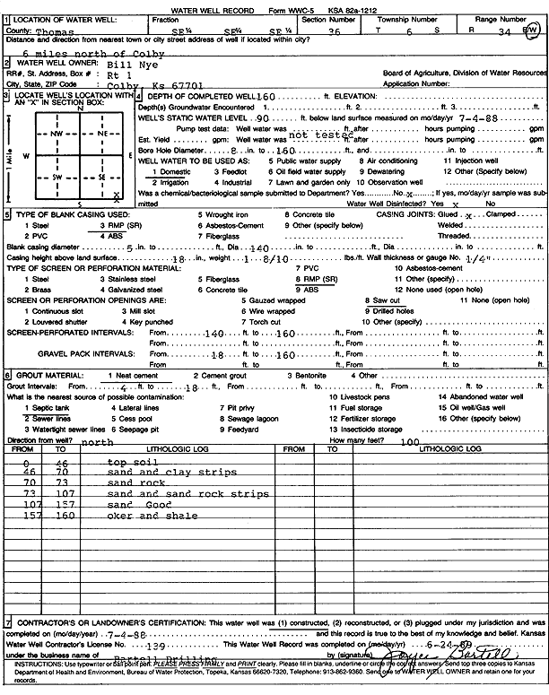
Specific Water Well Detail |
|
|
| Location Info | |||
| Owner: Nye, Bill | Status: Constructed | ||
| Location: T6S, R34W, Sec. 36, SE SE SE | County: Thomas | ||
| Directions: from Colby: 6 mi N | |||
| Latitude: 39.4821206 | Longitude: -101.0549686 | Datum NAD 27 | |
| Latitude: 39.4821232 | Longitude: -101.0554021 | Datum NAD 83 | |
| Longitude and latitude calculated by Survey from township-range-section-quarter calls. Only good to within the quarter call accuracy. | |||
| View well on interactive map | |||
| General Info | ||
| Well Depth: 160 ft. | Elevation: ft. | |
| Static Water Level: 90 ft. | Est. Yield: gpm. | |
| Comp. Date: 04-Jul-1988 | Well Use: Domestic | |
| DWR Applic. #: | Other ID: | |
| Driller Info | ||
| Driller: Robert Bartell Drilling & Machine Works | License #: 139 | |
| Scanned Form | View scan |
|
Chemical Sample Submitted?: No
Water Well disinfected?: | ||
| Ground water encountered: 0 ft. , 0 ft. , 0 ft. | ||
| Pump test data: Well water was 0 ft after 0 hours pumping 0 gpm | ||
| Casing Info | ||
| Casing Type: RMP(SR)
Casing Joints: |
Diam: 5 in. to 140 ft
Diam: 0 in. to 0 ft Diam: 0 in. to 0 ft | |
| Casing height above land surface: in
Casing Weight: lbs/ft Wall thickness or gauge no.: | ||
| Screen and Perforation Info | ||
| Screen Type: RMP (SR) | Screen Openings: Saw cut | |
| Screen-perforated intervals | From: 140 ft to 160 ft
From: 0 ft to 0 ft From: 0 ft to 0 ft | |
| Gravel pack intervals | From: ft to ft | |
| Grout Info | ||
| Grout used: Neat cement | From: 4 to 18 ft
From: 0 to 0 ft From: 0 to 0 ft | |
| Source of Possible Contamination | ||
| Source: Septic Tank | ||
| Direction from well: | Distance: 0 ft | |
| Lithologic Log
(Log data entered by KGS.) | ||
| From: 0 ft. to 46 ft. | top soil | |
| From: 46 ft. to 70 ft. | sand and clay strips | |
| From: 70 ft. to 73 ft. | sand rock | |
| From: 73 ft. to 107 ft. | sand and sand rock strips | |
| From: 107 ft. to 157 ft. | sand, good | |
| From: 157 ft. to 160 ft. | ochre and shale | |